Dr. Qassim Abdullah (right) visited the Grand Canyon recently with his younger son, Omar. Abdullah has been married for 40 years and has three children and four grandchildren.
Abdullah, chief scientist and senior associate at Woolpert, started his career as a civil engineer but was quickly drawn to surveying and photogrammetry, in which he earned his master’s and doctoral degrees. He said there has never been a dull moment in his 40-year career, thanks to ever-evolving geospatial sensor technologies.
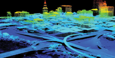
“Although I have participated in the development and introduction of many powerful geospatial tools (the digital camera, airborne GPS, inertial measurement unit, etc.), lidar has been the technology that continues to fascinate me the most,” Abdullah said. “In the mid-1990s, I was one of the few lucky individuals who had the opportunity to participate in the development of the first high-altitude lidar systems, which evolved to the ALS lidar system of today. Such a role gave me a better understanding and therefore appreciation of this technology. Lidar may sound like a simple physics, but in reality it is mind-boggling technology.”
When not discussing lidar and other geospatial topics, Dr. Qassim Abdullah enjoys running and competing in 50K and marathon races. He regularly runs about 25 miles a week. “Besides the health benefits, running helped me meeting new friends and taught me a great deal of patience, when you run 30 miles at a time and your body begs you to wrap it up, running teaches you to take it one mile at a time and that mile 26 will never come before finishing mile 25, it is a virtue of discipline and patience,” he said.
Abdullah was the creator and principal author of the new ASPRS Positional Accuracy Standards for Digital Geospatial Data Standards, which is focused on lidar data and digital imagery. He has been involved in the introduction of the new generation of lidar, most recently evaluating Geiger mode and single photon lidar in his role as a consultant for the U.S. Geological Survey (USGS). Through his data analysis, technologies evaluation and publications, Abdullah provides guidelines, conclusions and recommendations on the usefulness of the data from the new sensors for topographic mapping. He also is a member of Unmanned Aircraft Systems Standardization Collaborative, developing standards to facilitate the safe integration of drones into the U.S. National Airspace System.
Abdullah said helping author mapping standards and publishing his monthly “Mapping Matters” column in the PE&RS Journal have been “a few of the coolest things” he’s done in his career, while he said teaching graduate courses and workshops on geospatial subjects also has been immensely rewarding.
In addition to teaching classes at Penn State University and the University of Maryland, Dr. Qassim Abdullah conducts countless conference presentations each year. Here he is presenting at the 2018 Alaska Surveying and Mapping Conference.
“Writing and teaching makes me evaluate the industry from a layman’s perspective, and pushes me to read, investigate, test and develop the right answers and the needed applications,” Abdullah said. He added that his advice to those starting out in the geospatial field is to dedicate their careers to a topic they are most passionate about, that they can pursue with integrity, curiosity and hard work. “Passion drives you to persevere, curiosity pushes you to create and hard work gives you the time you need outside your daily routine. Like me, I tell them, they will find themselves working, reading or analyzing issues during holidays and weekends, while others are enjoying their favorite sports on television.”
That passion continues to carry Abdullah forward. Looking ahead to the future of geospatial technologies, he predicts a laser-based camera system that will be a lidar and multispectral camera at the same time.
“It will be a 3D imaging system that you can fly in the middle of the night,” he said. “But I don’t want to reveal too much about that now, as I am planning to publish an article soon on the blueprint of the design.”
Abdullah also just published a blog on geospatial trends for 2019, with topics that include big data, real-time GIS, robotics platforms, miniaturized sensors, cloud computing, marrying BIM to GIS, smart cities, mapping-as-a-service, and more. That was posted on woolpert.com in mid-January.
Abdullah said he is grateful to the industry in general and to ASPRS specifically for this most recent recognition.
“I am surrounded by this community of intelligent and creative friends and colleagues, who provide me with an invaluable technical and dynamic environment,” Abdullah said. “I am honored to be a part of this vital, thriving industry.”
The ASPRS Lifetime Achievement Award will be presented to Abdullah on Tuesday, Jan. 29, during the ASPRS Annual Conference and International Lidar Mapping Forum in Denver.