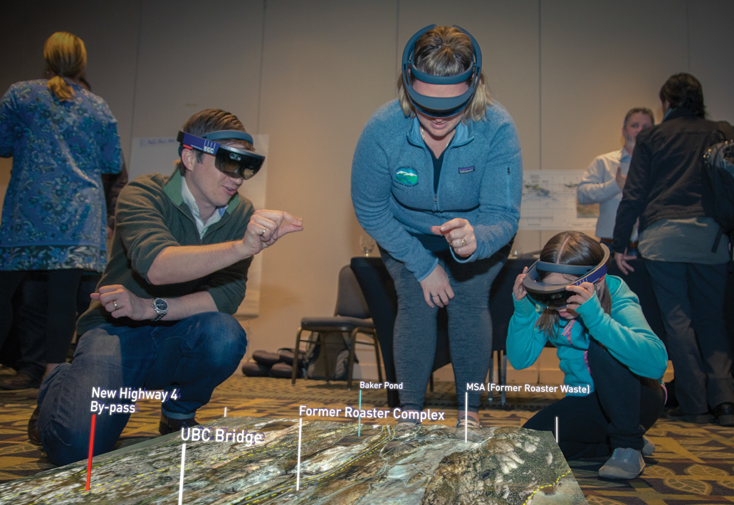
Figure 1: HoloLens model of the ALS data collected in the vicinity of the Giant Mine underground project, used at a community meeting.
Communicating complex engineering projects is highly intricate and complicated, especially on multidisciplinary projects that require community engagement and consultation. When projects are poorly communicated, opinions are formed and decisions made on incorrect interpretations or understanding of project details, leading to long-lasting impacts and consequences.
In today’s geotechnical engineering world access to three-dimensional (3D) data is commonplace and airborne laser scanning (ALS) data is particularly prevalent. Traditional means of communicating engineering designs and the terrain in which the projects are located, however, revolve around two-dimensional (2D) maps and drawings; this is a significant challenge when communicating 3D projects—and nearly all of them are 3D. Using 2D mediums to convey sophisticated 3D information poses a barrier to understanding by non-specialized participants, project team members or executives. Humans naturally think in 3D, not 2D, and exploiting this ability can fundamentally change how a project is understood by all stakeholders.
Editor’s note: A PDF of this article as it appeared in the magazine is available HERE.
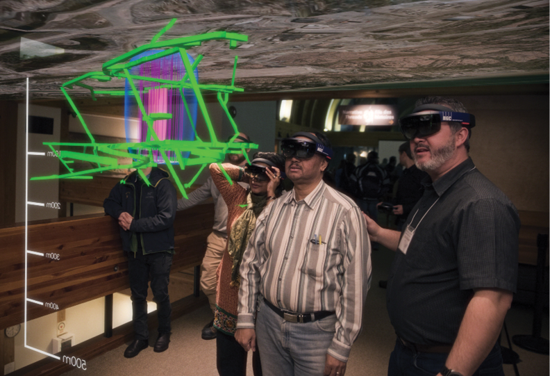
Figure 2: Stakeholders experience a HoloLens model of the Giant Mine underground remediation project.
As stated in the Harvard Business Review, “There is a fundamental disconnect between the wealth of digital data available to us and the physical world in which we apply it. While reality is three-dimensional, the rich data we now have to inform our decisions and actions remains trapped on two-dimensional pages and screens.”1
As an international applied earth science consulting firm with over 25 years of experience living the challenge of communicating 3D designs in 2D, BGC invested in developing software to bring projects to life through 3D holographic visualization. Our software, the Ada™ Platform, is usable on the Microsoft HoloLens, the world’s first self-contained wearable holographic computer. Ada combines 3D terrain and survey data, engineering designs, and real-time computer graphics. It enables experts and community members to walk around and interact with a virtual version of a project from any angle or point in time. Participants can visualize key elements in 3D at scales from high level overviews to true-life “boots on the ground” viewpoints. Visualizing information such as ALS data in 3D, on a holographic visualization platform, provides project participants with an unprecedented view of a project’s scope, scale, and technical details. Environments can be animated and presented at true scales to immerse the user in a project, from anywhere in the world. Furthermore, users can share environments and explore a design together.
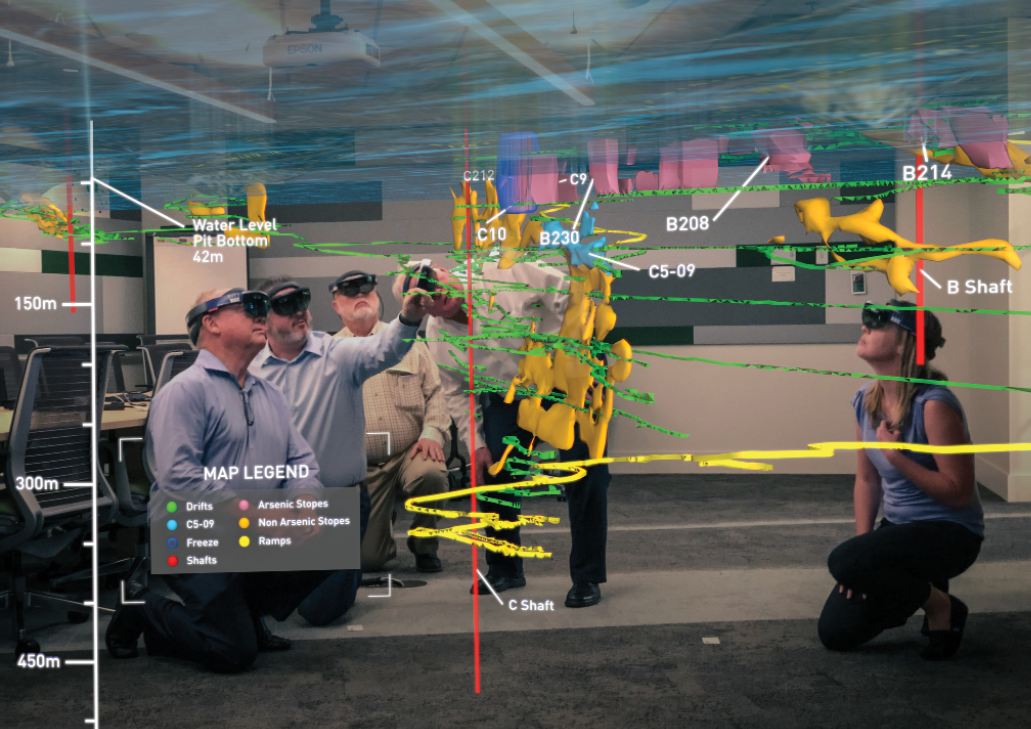
Figure 3: A group of experts using Ada at a review board meeting.
An example project that utilized Ada is for the Giant Mine remediation. BGC worked directly with Crown-Indigenous Relations and Northern Affairs Canada (CIRNAC) and the local community to foster better understanding and collaboration for an important environmental project. Giant Mine is an abandoned gold mine with a legacy of environmental concerns. One of the most notable issues is 237,000 tons of arsenic trioxide waste stored underground. The Giant Mine Remediation Project is a 10-year, $900 million cleanup focused on managing the arsenic trioxide waste and remediating the entire site.
As the mine is more than 600 metres deep and five kilometres long with a labyrinth of underground passages, it was difficult for CIRNAC to demonstrate the scope of the remediation project and describe how the team is working to protect the environment. With Ada we were able to bring together high resolution regional ALS data (2 pts/m2 bare earth), orthophotos, site specific vector-based information, and 3D models of the underground infrastructure into a single holographic environment (Figure 1).
By using Ada at community meetings, BGC and CIRNAC were able to help residents better understand the complexities of this project. “At CIRNAC, we were challenged with communicating and demonstrating the ongoing work and eventual impact of the remediation project for community members using complex 2D maps, drawings and schematics, so we were excited to hear about BGC’s Ada Platform,” said Chris MacInnis, engineering manager, CIRNAC. “With Ada, community members were able to ‘see’ the remediation work happening 600 metres below ground in a simple, lifelike 3D environment and easily understand how the arsenic trioxide is being contained.” See Figures 2 and 3.
Holographic visualization allows people to interact with and control their experience, which facilitates the generation of a deeper understanding of 3D data and environments and their changes over time. This is especially important for the comprehension of non-technical project participants. Holographic visualization is enabling clearer communication and more confident decision making. It will also help identify, anticipate, and mitigate challenges earlier within the project lifecycle by being able to visualize the site in 3D on a boardroom table or standing in the landscape. It creates a shared vision, a common reality that allows meaningful input and decisions to be made based on science, facts and evidence.
“It’s amazing to see how BGC’s innovative Ada Platform has leveraged Microsoft HoloLens technology to bring complex infrastructure projects to life in a way that simplifies, captures attention and creates better understanding,” said Mark Speaker, industry solutions executive, Microsoft Canada. “At Microsoft, we believe that mixed reality has the potential to transform the way people communicate, collaborate and explore. Like BGC, we’re excited about the opportunities that mixed reality brings to the future of mining.”
Mixed reality is a revolutionary step toward fully exploiting the potential of multidimensional data in a 3D environment. 
Matt Lato is a senior engineer at BGC Engineering, based in Ottawa, Ontario, Canada. His technical expertise is in the application of three-dimensional remote sensing in geotechnical engineering. Matt is author or co-author of over 100 journal and conference papers. He is an adjunct professor in the Department of Geological Sciences and Geological Engineering at Queen’s University, and an affiliate faculty member in the Department of Geology and Geological Engineering at the Colorado School of Mines. He holds BSc and PhD degrees from Queen’s University.