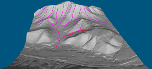
 Jan. 23rd, 2019 – VirtualGrid is pleased to announce the availability of VRMesh v10.2, the latest version of its powerful 3D point cloud and mesh processing software. This release has added a new feature that can automatically trace water flow paths.
Unlike traditional point cloud classification workflows that have to extract ground points first before classifying vegetation and buildings, the first fundamental step in VRMesh classification is to detect vegetation directly. The major benefit of our workflow is to make it working well under extreme variations in terrain. Furthermore, VRMesh meshing functions can create high accurate surface in details from ground points. The two key technologies: point cloud classification and meshing, promise VRMesh can trace water flow paths correctly.
YouTube Video: https://youtu.be/RzvvZMHDkTg
Meanwhile, some commands are enhanced. The distance widget supports slope calculation between two points. The Points by Slope command adds a value label to show the degree of a slope and allows you to export a screenshot to a PDF report. The two functions can be used to check out the floor flatness.
Additionally, the Pick Road Markings command is enhanced to trace polylines based on colored points from intensity as well as from RGB values.
For a live demonstration, please stop by Booth 810 at International LiDAR Mapping Forum 2019 in Denver from Jan. 28 – 30, 2019. We are pleased to show you our innovative technologies.
About VirtualGrid
VirtualGrid is the developer of VRMesh, an advanced 3D point cloud and mesh processing software tool. VRMesh can automatically process any point cloud generated from laser scanning or from photogrammetry. It can be used in many fields, such as land surveying, infrastructure, construction, mining, etc. Please visit our website www.vrmesh.com for more information.
