Nov. 1st, 2018 – VirtualGrid is pleased to announce the availability of VRMesh v10.1, the latest version of its powerful 3D point cloud and mesh processing software. VRMesh is best known for its unique technologies including automatic point cloud classification, feature extraction, high accurate triangle meshing, and advanced mesh editing. This new release has added new features and streamlined work processes to focus on point cloud cleanup and road resurfacing.
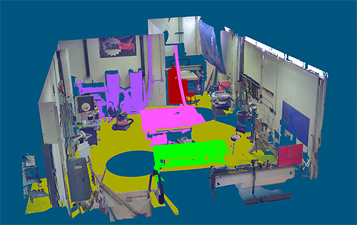 VRMesh v10.1 provides a simple and fast way for cleaning up and organizing point clouds. It adds a new feature for region reclassification, redesigns plane detection, and enhances the file split functions that allow you to classify BIM point clouds, separate points into different files, and export them directly into an Autodesk index file (*.rcp) for use in Autodesk software suites.
YouTube Video: https://youtu.be/AY7bvFm5jYo
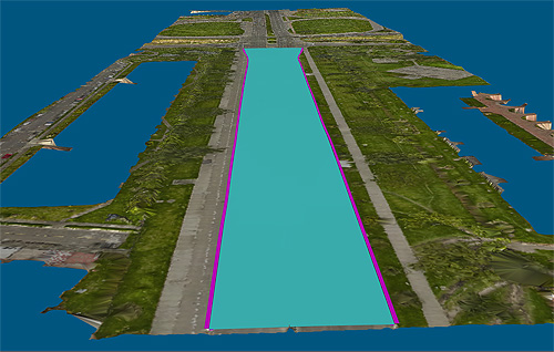 Meanwhile, a Terrain Resurfacing command is added with the aim of improving the workflow of road resurfacing. You can easily fit a spline surface on a terrain surface with the control of slope and elevation to generate a new surface. It can also be used to inspect surface roughness.
YouTube Video: https://youtu.be/Dl9S2TzTIhw
Additionally, the measurement features are improved with better labeling. The Measure Deviation command shows an accurate and easy-to-read cross section chart. The Inspection command adds value labels to an object in the main window and allows you to export a screenshot to a PDF report.
With this new release, VRMesh provides more flexible workflows for processing all kinds of point clouds generated from airborne, mobile, terrestrial LiDAR, or from photos. You can quickly classify and clean up point clouds, extract different feature lines, generate high accurate surface meshes from point clouds, and make an inspection between surfaces or measure deviations in the cross-section viewport. In short, VRMesh is an industry-leading software product that maximizes your productivity and makes your job easier.
For a live demonstration, please stop by Booth 310 at Autodesk University 2018 in Las Vegas from Nov. 13 – 15, 2018. We are pleased to show you our innovative technologies.
About VirtualGrid
VirtualGrid is the developer of VRMesh, an advanced 3D point cloud and mesh processing software tool. VRMesh can automatically process any point cloud generated from laser scanning or from photogrammetry, and can be used in many fields such as land surveying, construction, transportation, utilities, mine, etc. Please visit our website www.vrmesh.com for more information.
