 9 October 2018, Bologna, Italy – SITECO Infomatica SRL will be attending Intergeo 2018 in Frankfurt, Hall 12.0, Stand 12.OB.073, showcasing the Road-Scanner family of Mobile Mapping Systems and the NEW software release of Road-SIT Survey.
Road-SIT Survey is the mobile mapping data application developed by Siteco, fully compatible with the most widespread mobile mapping systems like the Optech-Lynx, Riegl-VMX, Topcon IPS3 and Leica Pegasus. And of course with the well known Siteco’s Road-Scanner.
 This new release has been developed in collaboration with the Bologna University Computer Vision Lab (CVLAB) and includes smart features for the point-cloud classification:
- Geometric classification which brings big advantages to edge detection and point-cloud editing;
- Semantic classification that allows a selective view of the point clouds and object detection through a sophisticated 2D and 3D deep-learning algorithm.
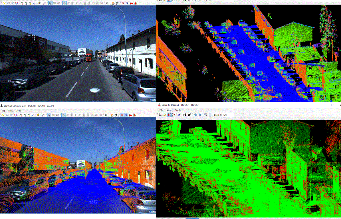
The geometric classification consists in computing NORMALS and CURVATURES in the neighbourhood of each point:
- The Normal is the direction of the tangent plane
- The Curvature is the degree of non-coplanarity:
 Both parameters are of a great help for edge detection and feature extraction.
The user interface has been improved in order to exploit the new features in the best way. In all the views and projections, the point clouds can be displayed in different color ramps based on: Intensity, Elevation, True color, Normals, Curvature, Semantic Classification.
For the NORMAL the RGB color ramp is: Blue = vertical (direction Z), Red = horizontal (direction X), Green = horizontal (direction Y)
For the CURVATURE: (GREEN=LOW=plane surfaces, RED=HIGH=edges , corners, natural elements like leaves and terrain)
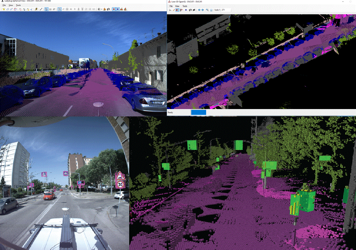
 The new display options are of great help to the feature extraction activities thanks to an real-time representation of the horizontal and vertical surfaces, allowing an immediate identification of the objects to be mapped (roads, furniture, buildings, signage, etc.) from others that can be considered as noise (vegetation, cars, pedestrians).
The curvature value allows the immediate location of the edges and makes it easier to extract them.
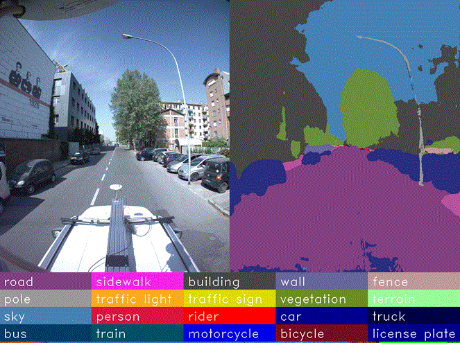
The Semantic Classification allows the automatic assignment, to every pixel of the camera pictures, of a LABEL with a class object, out of the 16 recognized classes of the neural network. It is then applied to the point-cloud, divided into 5-cm boxes (voxels).
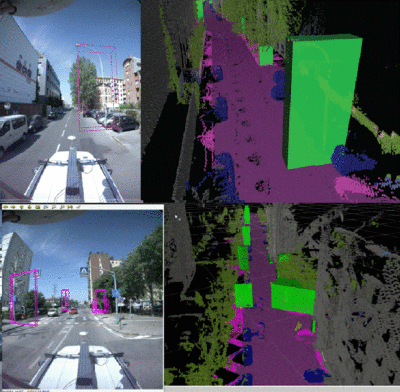
The new features include also the object detection for Signs, Posts, Poles and Buildings:
- The application detects clusters of adjacent voxels as single objects (poles, signs, buildings);
- Each of them is stored as a new object in a database with its position, picture and dimensional features;
- The detected objects can be edited in the feature extraction environment
The Technical Director of SITECO, Augusto Burchi, stated: “We are very proud of these innovative features. Thanks to them we are now developing new powerful functions for edge detection, object recognition and for registration of point clouds surveyed during different missions”.
About Siteco Informatica srl.
A unit of the Gavio Group, one of Italy’s top industrial groups. Siteco was established in 1995 as a civil engineering infrastructure, software and technical consulting firm. In 2005 they developed the first scalable, high performance fully integrated mobile mapping system and have since been delivering the most flexible roadway management mobile mappers in price, performance and software flexibility on the market.
