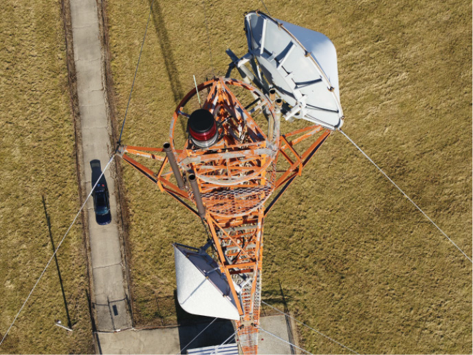
Woolpert uses high-resolution imagery to inspect infrastructure of all sorts, such as this communications tower. Courtesy of Woolpert
In 2013, the Association for Unmanned Vehicle Systems International (AUVSI) predicted that from 2015-2025 the integration of unmanned aircraft systems (UAS) into the National Airspace System would pump more than $82 billion into the U.S. economy, and create more than 100,000 jobs in the first three years. Since that study, continually emerging technologies for these compact, highly accurate and easily portable mapping tools have made those once-hyperbolic numbers seem downright conservative.
Today, the spectrum of commercial UAS applications is broad, ranging from product delivery and media coverage to precision mapping and worksite monitoring. For mapping and worksites specifically, UAS has proven invaluable because it can efficiently collect high-resolution, detailed oblique perspectives that cannot be provided by conventional land or other ground-based surveying tools within a small site.
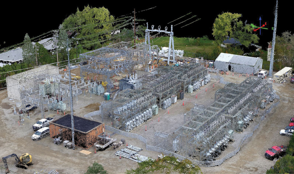
Woolpert used an unmanned aircraft system (UAS) to collect this colorized point cloud of a utility substation. Woolpert has used UAS in more than 100 projects since 2014 to collect data, monitor construction, verify safety issues, explore remote and tight locations and support airport asset management programs. Courtesy of Woolpert
The tool is ideal to monitor the status of construction progress or agriculture yield, explore and document remote or hazardous sites, provide accurate information in support of asset management systems, and verify safety issues and concerns at any location. These uses offer extensive value for multiple applications, providing visualization and verification tools for all involved parties from the start of a project to its completion.
UAS Applications: Assets for Asset Management
UAS has quickly become an asset to the commercial construction landscape because it provides fast, detailed and unlimited monitoring. A UAS camera that can see down to a quarter of a centimeter from 30 meters away can provide thousands of images from nearly any perspective to document the construction process. As technology improves, it will be possible to see detail as fine as the braids on a copper wire.
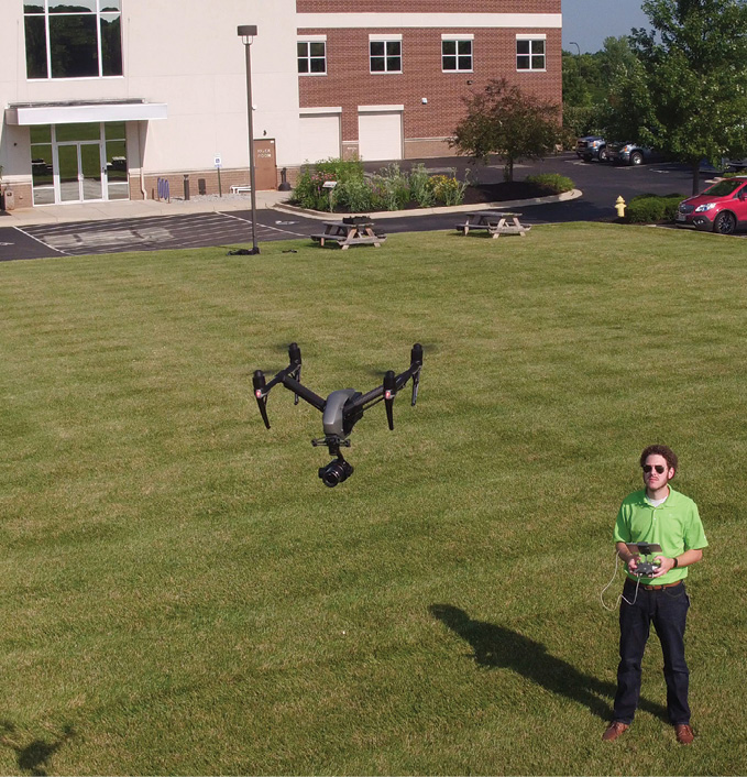
Ethan Schreuder, Woolpert UAS pilot, operates a drone outside Woolpert’s headquarters to demonstrate how the UAS can provide a digital record of a construction project. Photo courtesy of Ty Greenlees, Dayton Daily News)
This increasingly close inspection allows stakeholders to check whether materials meet the specifications of the project or if a lesser quality material was substituted. By collecting numerous datasets and providing those point clouds at specific construction benchmarks, UAS allows the client to literally watch their site being built online, making sure a project is proceeding on schedule and that contractors are maintaining a safe site.
The collection tool also eliminates the necessity for project managers to visit a site daily, saving travel time and lost job hours. UAS data can be delivered the day after flying. If any aspect of a project is raising concerns from neighbors or government officials, project managers can verify or dispute those concerns by simply referring to the latest data collected by the UAS, which can be within hours. “Concerned parties can track a project every day from the comfort of their office computer,” said Ethan Schreuder, Woolpert UAS pilot and survey technician. “We’re able to provide a 3D view of any project using easily accessible online visualization tools. It provides assurance, accountability and transparency throughout the build.”
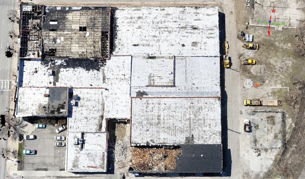
Woolpert uses UAS data to monitor construction as well as demolition. Above is a point cloud showing how demolition is progressing at a jobsite. Courtesy of Woolpert
This same process can be applied to multiple other worksites. Savannah/Hilton Head International Airport (SAV) recently began using UAS to support its daily airport and airfield operations. The airport, with integration guidance by Woolpert, has employed this tool to address wildlife management/hazard mitigation and daytime perimeter surveillance, routine needs for an airport that require a high level of safety and efficiency. According to Thomas Mackie, Woolpert vice president and geospatial aviation practice leader, this additional capability with UAS provides an opportunity to minimize frequency and duration of time spent in safety critical areas, while creating valuable geodata as part of the airport’s system of records. “Instead of driving up and down a runway to identify pavement or marking issues, the airport can use UAS to collect data remotely and create work orders with accurate coordinates and valuable imagery,” Mackie said. SAV is expanding UAS flight operations by using previously performed aeronautical surveys and base mapping as reference information to conduct asset management and change detection tasks. The UAS collects data remotely and provides immediately available and accurate imagery to determine, for example, whether a runway has a defect or burned out lighting.

Ethan Schreuder, Woolpert UAS pilot. Courtesy of Woolpert
UAS can also provide three-dimensional geospatial survey data and real-time inventory assessments to collect pre-construction and post-construction images in inaccessible locations, and provide a needed safety element. “Remote sites are the perfect use for this technology,” Schreuder said, noting that Woolpert has used UAS in more than 100 projects since 2014. “No one wants to fuel up a plane and fly out to the middle of the desert to collect for a couple of areas. At the same time, UAS is the most effective tool for nearby sites in which other collection methods would prove hazardous.”

Aaron Lawrence, GISP, Woolpert UAS Technology Manager. Courtesy of Woolpert
Another important application of UAS imagery is to identify potential structural and physical dangers before human climbers visually inspect aging aircraft navigation towers at sites across the country. “The UAS identifies structural issues associated with the climb, or if there are animals or insects living inside isolated structures such as these—and do so before a climber is 200 feet above the ground,” Schreuder said. “They still have to go up there but they know what tower section the bees are in or where the ladder is missing rungs. This allows the climbers to prepare and protect themselves better, and more efficiently complete their assessment.”
Safety and cost efficiencies also are components of UAS work at utility substations, allowing imagers to document ongoing conditions as utilities rebuild aging infrastructure or bring in new equipment. Dan Michalec, Woolpert geospatial specialist, said the firm has used UAS imagery and collected 3D lidar scans of multiple utility substations, recreating the geometry of each in a computer-aided drafting environment and providing geospatial data in a 3D colorized point cloud. The data allows each substation to be scanned to address safety concerns and determine the approach for 3D laser scanning and needed survey tasks to meet project requirements.
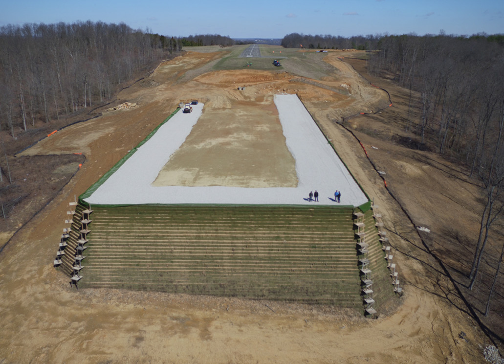
UAS data is being used to monitor the progress of construction on a runway extension, allowing stakeholders from different locations to watch as the project advances. Courtesy of Woolpert
In one case, a Leica P50 laser scanner was used to capture lidar and imagery data within the fence line, as well as all other features at the location. To identify the equipment, foundations and other site features, technicians classified the colorized point clouds into site-specific categories. The CAD files, 3D models, surfaces and point clouds easily identify buildings, equipment, ground elevations, fence lines, utilities, storm and sewer manholes, foundations, cable trenches and other features in each substation.
“Safely installing new or replacing old equipment often requires a disruption of service to customers, so time is critical. That’s why flights are planned strategically around outages,” Michalec said. “This way, data acquisition is optimized to support construction scheduling and customer impact. By arranging flights around key tasks, UAS data provides a clear picture of site conditions prior to taking equipment offline or energizing site components. As the quality of UAS data increases, end users can utilize the accuracy of terrestrial lidar datasets and the quick responsiveness of UAS datasets to build unparalleled site visualizations.”
The benefits realized by utility companies mirror those of construction projects, including access to current digital data, reduction of construction errors, minimized rework in the field, increased safety with fewer construction workers exposed to electricity, decreased travel time and fewer work hours lost.
Expanding Relationship of Lidar and UAS
UAS data is not expected to replace manned aerial lidar collections for large projects, such as mapping entire states or countries, because this would not be economical. However, where large areas have been carpeted with lidar data, integrating UAS-collected data provides a swift and cost-effective way to capture and update smaller areas within the larger dataset coverage. Additionally, the use of UAS for collection of smaller project areas to get a better understanding of the 3D environment at much higher resolution is achievable.
“If an accurate and comprehensive surface is critical, lidar is best,” Schreuder said. “If you need to see if a fuse was installed correctly, high-resolution imagery from UAS is ideal. UAS will tell you whether a construction project is on track and provide a digital record, and can verify that information rapidly.”
In many cases, existing lidar can assist in flight planning, conducting line-of-sight analysis prior to arriving on site. UAS also can make outdated data useful again. For example, states that have completed lidar mapping of large areas don’t have to spend the money to remap after a new subdivision has been completed. UAS can provide the images to insert a patch into the existing data.
Collecting lidar data via UAS for commercial applications has also been gaining acceptance. While there have been significant advances in miniaturizing lidar, as well as GNSS and inertial measurement unit (IMU) technology, for integration on UAS, there is still discussion and evaluation as to whether an integrated lidar system is capable of producing the highly accurate data products currently being achieved by conventional methods. “The technology will only become more accurate,” Schreuder added. “Cameras and UAV lidar will only get better.”
The addition of hyperspectral sensors advances the potential for commercial UAS uses beyond 3D. Hyperspectral sensors have been miniaturized to the point where 300 spectral bands can be collected from a sensor the size of a golf ball, enabling specific materials to be identified via their spectral signatures. Applications of hyperspectral imagery in the field of agriculture currently allow seed manufacturers to use UAS data collection to determine which product was the most effective and productive in a field, or to detect weeds or insect or mold issues that limit the yield. The data gathered by UAS helps provide information about the condition of the soil or whether crops need increased irrigation, or assists in remotely planning the most efficient methods to boost crop production levels. U.S. Department of Agriculture and Forest Service officials also could use hyperspectral imaging collected by UAS to ascertain whether an invasive insect, such as the emerald ash borer, has decimated the interior structure of a 100-foot-tall tree. Having and sharing this information can save lives, homes and other infrastructure by addressing the affected trees before Mother Nature crashes the scene.
“The bottom line is that there is literally no limit to the collection and application of UAS and lidar data, whether they are used independently or together,” Schreuder said. “Understanding these tools and employing these technologies appropriately allows the most effective, precise collections, which then yield the highest-quality results.” 