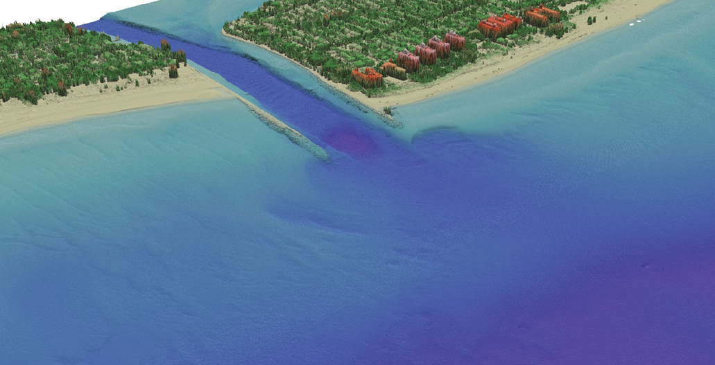
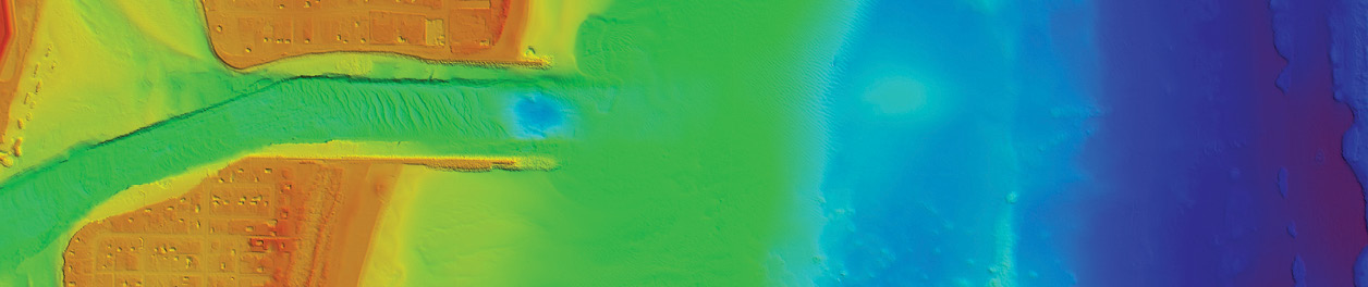
The data in these images was acquired May 21-22, 2016, with the CZMIL topographic/bathymetric lidar system and processed with HydroFusion software, then cleaned in PFMABE. The data was classified and products developed through GeoCue’s LP360 software and used to identify the position/condition of the inlet jetties, as well as the surrounding beach and dunes area in the Lake Worth Inlet area of Florida. The elevation/bathymetric range was 28 meters, relative to NAVD88. This data is courtesy of the USACE National Coastal Mapping Program.
Knowledge is power, and the more we know the stronger we become. In times of distress or disaster, acquiring highly accurate information becomes crucial to recovery and resilience.
Natural disasters cause severe damage to natural and man-made infrastructure across the country. Hurricanes in particular wreak havoc on the shorelines and inlands of coastal states, degrading the integrity of the coasts. Ascertaining the impact made by these disasters better equips disaster response in the short and long term.
When Hurricane Matthew hit the Southeast in October 2016, the Joint Airborne Lidar Bathymetry Technical Center of Expertise (JALBTCX) contracted with WMR-532, a joint venture between geospatial mapping firms Woolpert and Optimal Geo, to acquire bathymetric and topographic lidar and imagery data to provide an immediate, accurate assessment of the affected regions. JALBTCX supports the coastal mapping and nautical charting requirements of the U.S. Army Corps of Engineers (USACE), the U.S. Naval Meteorology and Oceanographic Command, the National Oceanic and Atmospheric Administration (NOAA) and the U.S. Geological Survey (USGS).
USACE deployed JALBTCX for regional-scale, post-storm damage assessments after several major extreme storm events in 2004 (Charley, Frances, Ivan, Jeanne), 2005 (Katrina, Rita, Wilma), 2008 (Ike), 2012 (Sandy), and 2016 (Matthew). JALBTCX deployed for the Federal Emergency Management Agency (FEMA) in 2005 (Dennis) and 2017 (Irma).
In an abbreviated, four-week time frame, WMR-532 used state-of-the-art, government-owned coastal mapping sensors to provide post-storm data for the shorelines of five states, from Florida through Virginia. The data was processed 24 hours a day in the field and compared to data flown just months earlier, enabling USACE scientists and engineers to analyze and quantify coastal change and beach erosion, and to rapidly identify and address navigation hazards caused by Hurricane Matthew.
Data for this project was collected at an altitude of 400 meters, or 1,300 feet. The horizontal and vertical accuracy of the topographic lidar data was acquired to meet or exceed the USGS Quality Level 2 standards (QL2).
This data is courtesy of the USACE National Coastal Mapping Program.
“Timely information is a key component to identifying the needs for disaster recovery,” said Mark Brooks, chief operating officer of Optimal Geo. “JALBTCX was able to provide USACE Districts, as well as other federal and state agencies, the necessary data to make well-informed, and nearly-immediate, recovery decisions.”
Path of Hurricane Matthew
The annual USACE National Coastal Mapping Program (NCMP) operations began in January 2016 in Puerto Rico and resumed in the conterminous states in early May, continuing along the east coast of Florida from late May through July, the Gulf coasts of Florida, Alabama and Mississippi from late July through September, and along the Gulf coast of Texas in September and October by utilizing dual aircraft operations.
Tropical Storm Matthew was declared on 28 September 2016 and grew into a Category 1 hurricane within 24 hours. It reached its peak strength as a Category 5 on 1 October, in the Caribbean Sea just north of the Venezuela/Colombia border. It weakened to a Category 4 as it traversed north through the Windward Passage between Haiti and Cuba, entering the Bahamas as a Category 3. The hurricane started losing strength as it approached the southeast U.S., side-swiping both Florida and Georgia before making landfall in South Carolina as a Category 1 on 8 October.
Given such a large impact area, USACE South Atlantic Division requested JALBTCX support to capture the condition of USACE projects between Miami and the border between Maryland and Virginia. Extending over 1,000 miles, this stretch of coast contains 35 USACE beach projects designed to reduce the risk of coastal storm impacts and numerous navigation projects that support commercial and recreational shippers, fishers and boaters.
“The importance of these datasets, by that I mean current pre-event data and rapidly delivered post-event data, cannot be understated,” said Jennifer M. Wozencraft, USACE NCMP manager and director, JALBTCX. “They allow us to quantify impacts to the coastal environment and infrastructure, and support response activities. But more than that, they help us understand where our vulnerabilities are and how the coastal system responds and give us a baseline for recovery so that we can better adapt, prepare and respond to future storm events.”
USACE and WMR-532 equipment and personnel were mobilized from Kiln, Mississippi, starting on 27 October, about 20 days after Hurricane Matthew made landfall in South Carolina and 10 days after the 2016 NCMP operations were concluded in Texas. By the conclusion of the project on 2 December, 991 flight lines had been flown in 76 sorties.
USACE engineers and scientists compared data collected under this contract to data successfully collected along the east coast of Florida in the summer of 2016, just four months before the storm made landfall. For the coasts of Georgia, South Carolina, North Carolina and Virginia, USACE utilized previous NCMP data sets and data sets acquired by federal mapping partners in the Interagency Working Group on Ocean and Coastal Mapping.
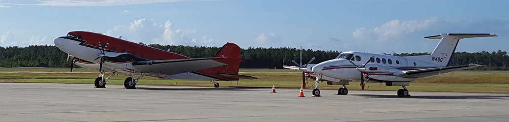
The Dynamic Aviation King Air 200 (right) and Kenn Borek Air Basler BT-67 were used in the post-Matthew lidar collection, carrying the CZMIL sensor, owned by USACE and JALBTCX.
Photo courtesy of Optimal Geo.
“JALBTCX had current data to utilize and, as Matthew was the first major storm since that last National Coastal Mapping Program acquisition, this project provided exceptionally precise, and temporally relevant, post-storm coastal change analysis,” said Mark Smits, Woolpert program director. “Having these resources at hand exponentially increased our application of this data, opening up multiple exciting technological opportunities.”
Four field teams were deployed at a Post-Matthew Operations and Production Center in a St. Augustine, Florida, hotel. A staff of between seven and 20 people worked around the clock during those 36 days. Each of the 12 workstations was equipped with a minimum of 32 CPUs, 192 GB of RAM and dual monitors to facilitate the data processing and editing tasks in the hotel’s conference room.
Personnel on site included USACE and WMR-532 staff, supporting the data acquisition and data production efforts. Personnel numbers were higher at the start of the post-storm response to support dual aircraft operations, project coordination and oversight. Once flight operations were complete, personnel numbers decreased to levels appropriate to complete the data production in the field.
Data from this rapid-response mapping effort was developed into standardized NCMP lidar and imagery data products, and advanced data products for use in storm damage and impact assessments by USACE staff. The data delivery schedule called for the delivery of rapid-response data products two days after initial data acquisition, while advanced lidar products were to be delivered two weeks after acquisition.
“Housing JALBTCX’s Operations and Production Center in St. Augustine was pivotal in responding to the data needs of scientists and engineers at Jacksonville District,” said Charlene Sylvester, USACE senior technical staff member at JALBTCX and post-Matthew QA/QC and production manager. “The site selection afforded opportunities for face-to-face discussions of priority areas, data requirements and product development methodologies to ensure that the data met Jacksonville’s science and engineering requirements in a timely fashion and in a data format that was compatible with existing geospatial applications.”
Technology Involved in Collection
The sensor used in the post-Matthew collection, Optech’s Coastal Zone Mapping and Imaging Lidar (CZMIL), is owned by USACE and JALBTCX, and was installed and flown in a Dynamic Aviation King Air 200 and a Kenn Borek Air Basler BT-67. The combination of aircraft and sensor efficiently and effectively performs on both high-altitude and low-altitude aerial data acquisition.
The CZMIL sensor, operations, and processing are particularly well suited to meet requirements for post-storm mapping. CZMIL is a bathymetric lidar system with capability to collect QL2 topographic lidar, aerial photography, and hyperspectral imagery at the same time. In areas where the water is clear, it can measure sand that has moved off the beach to form sand bars in the nearshore, which is a common beach response to coastal storms. It also is able to measure depths in tidal pools that develop between the beach face and sand bars as they move back onshore, which is a common natural beach recovery mechanism after storms. CZMIL is a low-flying, circular scanning, waveform-resolving lidar, which gives it a unique capability to see through dense vegetation, such as sea grapes, to accurately measure the shape of coastal dunes. The ability to measure these features is key to precisely computing changes in beach elevation and sand volume due to storms.
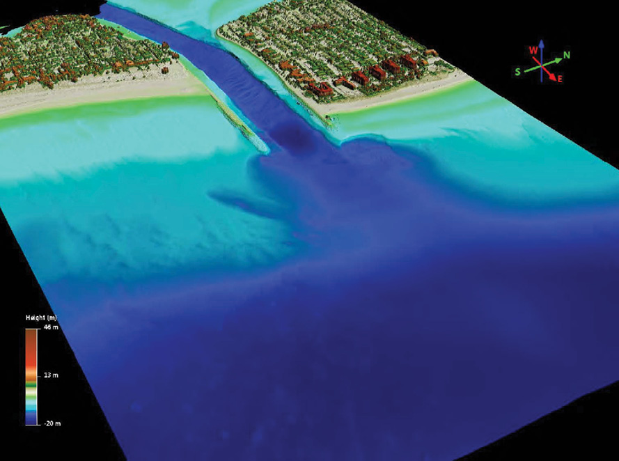
This topographic and bathymetric 1-meter digital elevation model near-shore lidar data was captured over Palm Beach Inlet, Florida. This data was utilized in conjunction with the 2017 post-Irma survey data to calculate damage.
This data is courtesy of the USACE National Coastal Mapping Program.
Mission plans for the post-Matthew project were generated in HydroFusion software, which is unique to JALBTCX’s CZMIL sensor suite. Shore-parallel flight lines were organized into 117 flight blocks with 25 percent overlap between adjacent flight lines. A single cross-line per flight block was also planned. An operational altitude of 400 meters above ground level yields a flight line swath width of nearly 300 meters. This altitude is ideal for coastal areas, where cloud deck is low during normal weather, especially during the aftermath of storms.
Post-storm mapping differs from normal airborne survey operations in that data must be collected as quickly as possible after the event to capture the maximum damage of the storm, regardless of weather and water conditions, requiring careful management of the operation of two aircraft in higher than normal water level and wave conditions, and around the priorities of USACE. The goal was to capture USACE projects along Florida’s east coast at the outset of this effort, as the USACE projects in the Jacksonville District sustained heavy damage. Wave and water conditions were not optimal for data acquisition during the first several days of operations, which led to the decision to capture projects in the Charleston and Savannah districts first. It took nearly two weeks to complete acquisition for all USACE project priorities.
CZMIL’s robust calibration, low flying altitude and intensive QA/QC protocol ensure data with 10 cm RMSEZ on land and in shallow water without the need for ground control or GNSS base station support. Final data accuracy is validated against prior datasets collected for NCMP and against datasets collected by other sensors. CZMIL operations can be performed without putting a single person at risk in high-hazard post-storm impact areas, or consuming resources such as gas, food, water, rental cars, and hotel rooms that may be needed by people displaced by the storm, or by emergency responders.
JALBTCX employs a standard data production workflow for data acquired under NCMP. The production workflows have been developed in collaboration with USACE staff to ensure that the products meet the needs of engineers and scientists. For this project, the data was processed in the field from raw lidar waveform to edited, unclassified point clouds using the HydroFusion software in conjunction with Pure File Magic Area Based Editor (PFMABE) software. Edited flight line point clouds were then run through an industry-standard ground classification routine and tiled into 1-kilometer-by-1-kilometer tiles per the Military Grid Reference System in Terrasolid’s TerraScan environment.
Quality control of those classifications and any further editing was accomplished in GeoCue’s LP360, bulk datum transformations were accomplished in NOAA’s VDatum, then products were generated using Applied Imagery Quick Terrain Modeler and Esri ArcGIS. The data was delivered to key stakeholders with ISO 19115-compliant metadata using secure ftp. JALBTCX also partnered with NOAA, as it has for NCMP, to provide the data through NOAA’s Digital Coast web application.
In post-storm response mode, CZMIL data are delivered in a rolling fashion; that is, data collected on Day 1 are delivered on Day 3, Day 2 data are delivered on Day 4 and so on. It is not necessary to collect the entire project area to deliver final, classified point clouds that meet QL2 accuracy specification.
Looking ahead
Since Hurricane Matthew, there have been additional opportunities to utilize these processes and technologies to monitor and protect our nation’s coastlines—as happened in early September 2017, when Hurricane Irma hit Florida. WMR-532 again supported JALBTCX in collecting data in the storm’s path. The scale of Irma’s impact was assessed by comparing immediate post-storm data to the previously collected data in order to conduct a coastal change analysis. The post-Irma data were collected for FEMA to determine eligibility of coastal communities to receive public assistance to reimburse installation of emergency protective measures.
We cannot predict where the next disaster will strike, but better preparation is well within our control. Jeff Lovin, Woolpert senior vice president and director of government solutions, said that by continuing to refine proven processes, protocols and technologies, the ability to respond and recover vastly improves.
“We created the joint venture as our primary objective is to support the widespread mapping needs of USACE and JALBTCX,” said Lovin. “By enlisting WMR-532, JALBTCX gets the experienced flight crews, field support staff and data processing to support post-storm recovery efforts, and we will continue to apply the most effective resources toward that end.”