
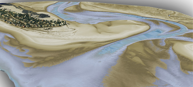
Superstorm Sandy: Lidar topo-bathymetric model displays terrestrial as well as near-shore underwater surfaces along Atlantic Coast. Image courtesy of NOAA and USGS.
Hurricanes, flooding, landslides, wildfires and erupting volcanoes—rarely a week goes by when you don’t see headlines about these types of natural disasters, which result in untimely deaths and billions of dollars of damages to personal property. But what if we could better understand our geography and use that information to prevent or mitigate potential problems?
The technology to do that exists, and it’s called light detection and ranging, or lidar. This cutting-edge survey technology uses lasers to scan the earth, collecting high-definition surface information in 3D. Not only does lidar enable users to pinpoint key features, it also helps reveal critical information relating to both the natural and built environments.
There is a seemingly endless potential for the use of lidar, and the key is finding a way to collect the data and make it readily available to all those who need it or could benefit from it. For many small agencies or individual organizations, lidar surveys can be cost prohibitive, no matter how valuable the resulting insights. That’s where programs such as the United States Geological
Survey (USGS) 3D Elevation Program (3DEP) come in.
What is 3DEP?
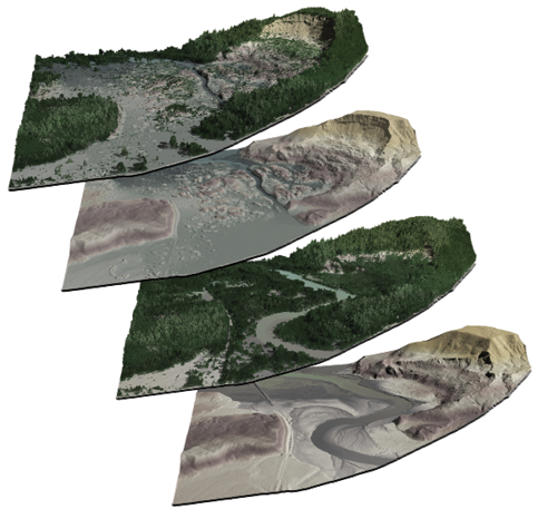
Four images show the before and after effects of the Oso Landslide, comparing both surface and bare-earth models.
Now in its fifth year, the 3DEP initiative was developed in response to the growing needs for high quality topographic data and a wide range of other three-dimensional representations of the Nation’s natural and constructed features. The primary goal is to systematically collect enhanced elevation data in the form of high-quality lidar for the conterminous United States, Hawaii, and the U.S. territories, over an 8-year period.
Each year, partnership proposals are accepted through the Broad Agency Announcement (BAA), providing federal matching funds to help finance large-area lidar collections which benefit multi-agency groups with common geospatial needs. This helps individual agencies minimize the costs while also improving the impact of the data collected. Over the last five years, this program has contributed more than $27 million in partnership funds, covering approximately one-third of the cost of acquiring 175,000 square miles of new lidar data for some 18 projects across 22 states.
Lidar data collected as part of 3DEP is valuable to a number of disciplines, including water resource planning, natural resource conservation, precision agriculture, geologic hazard mapping, wildlife management, mineral deposit sourcing, transportation, urban planning, and infrastructure management.
Already we’ve seen the value of lidar data and analytics applied in real-world scenarios.
Oso landslide
Following this tragic landslide, which resulted in 42 deaths, officials began conducting lidar surveys across the State of Washington. Using the data collected, geologists have been able to perform analyses and risk modeling to identify landslide deposits and hazard zones, bringing attention to areas where there is potential for landslide activity that could adversely impact infrastructure or public safety.
Hurricane Sandy
After one of the deadliest and most destructive events of the 2012 Atlantic hurricane season, high-resolution topographic and bathymetric elevation data was collected using lidar technology along the eastern seaboard from South Carolina to Rhode Island. The insights gained from this survey are assisting with hurricane recovery and rebuilding activities; assessments of shoreline vulnerability to coastal change hazards, such as severe storms, sea-level rise, and shoreline erosion and retreat; validation of storm-surge inundation predictions over urban areas; and watershed planning and resource management.
Rio Grande flooding

Lidar surface model of the Rio Grande at El Paso, Texas. Image courtesy of USGS.
Not only is flooding one of the most common and costly disasters, flood risk can change over time as a result of development, weather patterns and other factors. A 3D lidar surface model was created for the City of El Paso, Texas, to identify areas at risk of flooding and support planning and outreach to communities in order to help them take action to reduce or mitigate flood risk.
How can my organization get involved with the 3DEP program?
The projects detailed above represent only a few of the ways lidar can be used. If you have a project in mind, it’s time to start preparing now. The central tenet of 3DEP projects involves creating a coalition of stakeholders. With that in mind, you’ll want to begin reaching out to others interested in collecting lidar data in your region and discuss the potential project scope.
The first official step for fiscal year 2018 3DEP will take place in early August when USGS issues its BAA, the competitive grant application. USGS offers background information on the BAA process through webinars and in-state presentations, details of which are at nationalmap.gov/3DEP/3dep_about.html.