Leica Geosystems, Matterport Partner to Combine Digital Reality, Immersive Media
 Norcross, Ga./Sunnyvale, Calif., 13 June 2018—Leica Geosystems, part of Hexagon, industry leader in measurement technology, and Matterport, an immersive 3D media technology company, today announced the availability of a reality capture solution for the real estate and Architecture, Engineering and Construction (AEC) markets.
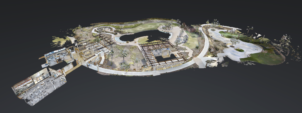
Leica Geosystems redefined the imaging laser scanner market with the launch of the Leica BLK360, the world’s smallest and most powerful portable 3D imaging laser scanner. The Matterport media platform makes it easy for anyone to create immersive 3D and digital reality versions of real-world spaces for the web, mobile and tablet devices, and VR headsets.
The integration between the Leica Geosystems BLK360 and the Matterport platform is relevant to a wide variety of industries, especially in the residential and commercial real estate as well as AEC markets. For example, in commercial real estate you can engage decision makers and add critical value to the buying/leasing process with dimensionally accurate 3D walkthroughs.
Reality capture simplified
Through the power of the BLK360 and the Matterport reality capture and cloud platform, capture has become a simplified process where spaces can be digitised with just the touch of a single button. The interoperability of the BLK360 and Matterport’s reality capture platform provides users an easy-to-use solution that can be used by anyone, anywhere, bringing a new means of delivering immersive 3D content.
“As space-as-a-service becomes the mantra for the real estate industry, real estate developers, property owners, space planners and agents need a streamlined way to digitise their offerings,” said Hexagon’s Geosystems Executive Vice-President Ken Mooyman. “With Hexagon’s expertise in 3D reality capture, combined with Matterport’s computer vision capabilities, real estate and AEC professionals can now access the high-quality content needed to create digital realities of real-world spaces from anywhere in the world.”
“By partnering with forward-thinking companies like Leica Geosystems, we are furthering our mission to democratise immersive 3D technology, making it easy for anyone to capture and distribute high-quality virtual experiences,” stated Matterport CEO Bill Brown. “A broader set of customers will now be able to easily harness Matterport’s powerful media platform, giving them more options for reality capture solutions and significantly aiding in the decision-making process throughout a property’s lifecycle. We’re excited to help these professionals enhance their offerings with our technology.”
Attendees of HxGN Live 2018 were able to witness the the integration between Leica Geosystems’ and Matterport’s technologies first-hand via numerous demonstrations.
For more information about the Leica BLK360, please visit
leica-geosystems.com/en-us/products/laser-scanners/scanners/blk360. For more information about Matterport, please visit matterport.com.


Leica Geosystems Combines New UAV Technology with DJI Aerial Platform
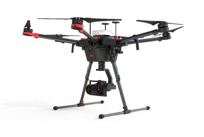 Heerbrugg, Switzerland, 12 June 2018—Leica Geosystems, part of Hexagon, industry leader in measurement technology, announced today the new Leica Aibot, the latest Unmanned Aerial Vehicle (UAV) system based on DJI’s aerial platform, the M600 Pro, to rapidly and autonomously acquire mobile 3D mapping data.
The new Leica Geosystems UAV technology allows users to get a complete data set in less time with a user-friendly and innovative interface, opening new business opportunities while spending less time, costs and effort than with traditional methods. Leica Geosystems software suite supports the new UAV workflows. Using Leica Infinity for point cloud, digital surface model and orthophoto generation enables surveyors to easily process and visualise aerial data to maximise productivity and speed-up data delivery. Supporting users to share data to Cylcone and Cloudworx, the integration of the UAV point cloud with terrestrial scan data enables users to make the most informed decisions. This complete set of data results in higher project efficiency.
“With constant new ideas, projects and numerous challenges it is crucial for our business to have access to transformational technologies such as the new Leica Aibot, that keep our projects on schedule with the maximum accuracy and precision,” said Martin Schwall, owner and managing director of IngenieurTeam GEO. “We look forward to continue using Leica Geosystems technology and adding Leica Aibot to our portfolio.”
Automating operations
The new UAV technology, developed in partnership with DJI, the world’s leading manufacturer of UAVs, allows users to process and analyse millions of data points gathered from above and visualise the data to provide actionable information. UAV data can be combined with existing survey technologies, such as TPS, GPS and laser scanning, providing a more complete set of information.
“We are very excited to offer our robust and reliable DJI M600 Pro along with our developer tools to Leica Geosystems to empower survey professionals to get a truly efficient solution workflow with the best results and accuracy,” said Jan Gasparic, Head of DJI Enterprise.
Throughout a project lifecycle of planning, designing and construction, Aibot provides easier access to critical information to perform volume calculations and monitor site progress. From creating digital terrain models to stripping and bulk earthworks and trenching to finally fine grading, paving and compaction, the solution supports easier actuals comparisons. This provides a more transparent view of site progression monitoring and volume calculations with safer operations to keep projects on schedule.
The Aibot can identify gaps early with a level of accuracy previously unknown for the construction industry. High definition imagery and 3D mapping allow for the viewing of site mapping or progress documentation, meaning users save time and money at all stages of the project.
“The Leica Aibot opens tremendous amounts of opportunity and helps the customers to speed up digitisation of processes and to automate existing workflows,” says Valentin Fuchs, Leica Geosystems UAV product manager. “It enables customers to run businesses that are more efficient than their predecessors and be more profitable.”
Further information about the Leica Aibot can be found at leica-geosystems.com/products/uav-systems.

SimActive Software for Precision Agriculture in Brazil
 Montreal, Canada, June 12th, 2018—SimActive Inc., a world-leading developer of photogrammetry software, is proud to announce use of its software for precision agriculture in Brazil by Portal Produtos Agropecuários Ltda (Portal). Drone data is transformed into useful and pertinent information for farmers with Correlator3D, leading to optimized yields and reduced costs for the agricultural season.
The identification of the presence and damage caused by centipedes was one such example. When plant samples from the field were collected to identify the source of the growing anomaly, Portal was able to fly and generate mosaics to spot the problem within 24 hours using Correlator3D and their drones.
“Correlator3D is agile, reliable, and efficient in processing the high-resolution UAV data we collect, generating high quality mosaics every time”, said Valdir Rago, Agronomic Engineer at Portal. “We tested other commercial UAV data processing apps and found that Correlator3D was the best at delivering the results we need. The friendly interface, also accessible in Portuguese, along with round the clock support from SimActive’s partner in Brazil, ENGESAT, put them in a different league.”
For More Info visit www.simactive.com

The INTERGEO conference is training the spotlight on digitalization from various perspectives
Karlsruhe/Frankfurt am Main, 20 June 2018—INTERGEO 2018 presents the ideal opportunity to explore key topics surrounding the digital revolution, smart cities and ever-advancing technological developments such as artificial intelligence and augmented and virtual reality. Tickets for the conference and trade fair are available now. Keynote speeches, panel discussions and industry-focused exhibitions will demonstrate the bright prospects for the future geodata industry.
When it comes to digitalisation, the question on everyone’s lips is “where?”. This is precisely where geodata comes in. Geodata forms a key part of each digitalisation process and is often needed to make such processes worthwhile and understandable. Google is a prime example with Google Maps. “Geodata naturally plays a vital role in digitalisation, as we live in a 3D world where something is always happening somewhere,” says Prof. Hansjörg Kutterer, President of the INTERGEO host, DVW (German Society for Geodesy, Geoinformation and Land Management). “A digitalised world calls for geodata. It is essential for smart cities, as various forms of specialist data can be combined with digital geoinformation to provide new findings. The data can then be used for a whole range of purposes, from generating forecasts to providing services. Just think of the tasks in urban and traffic planning, environmental protection or disaster prevention, for instance. The world of work will fundamentally change, as will citizens’ expectations. Only by incorporating geodata can we turn elementary applications in the cities of the future into smart solutions.”
That’s why the smart city solutions section constitutes the focal point of the trade fair. An important partner in this respect is the Fraunhofer Institute for Industrial Engineering (IAO), which is working hard to address the subject and will give a keynote speech on the Wednesday with Alanus von Radecki to provide visitors with an expert insight.
Smart traffic management by means of autonomous driving, digital urban planning, digital construction and property valuations are just some of the main focuses at the conference. Prof. Joaquin Diaz from the Federal Association of Construction Software (BVBS) and Prof. Harald Simons, member of the management board at empirica AG, will kick off the final day of the event with a keynote speech on these subjects.
Looking at infrastructure measures, Ron Bisio from Trimble will give a keynote speech on building information management (BIM) and highlight the potential of state-of-the-art geospatial technology.
Even now, vast amounts of precise and cutting-edge geodata are being collected. AI has the potential to make data capture and evaluation processes significantly faster, which will see construction procedures and traffic management undergo revolutionary changes in the future. AI planning expert Prof. Jürgen Döllner from the Hasso-Plattner Institute will open the event with a keynote speech focusing on the different uses of AI.
The visualisation of geodata is increasingly based on high-resolution, photorealistic virtual reality (VR) applications that exhibit state-of-the-art imaging and scanning processes. On top of that, there are augmented reality (AR) applications that enable users to directly access location-specific data that can be geographically and seamlessly combined with a digital 3D depiction of the area.
INTERGEO is the world’s largest trade fair for geodesy, geoinformation and land management and therefore provides a fantastic platform, forum and opportunity to network. The 2018 event will be held in Frankfurt am Main, Germany, from 16 to 18 October.
Dewberry Selected to Update High-Resolution Lidar for Puerto Rico and
U.S. Virgin Islands
Firm will produce more than 3,600 miles of post-Hurricane Maria topographic lidar data
Fairfax, VA—June 6, 2018—The U.S. Geological Survey (USGS) has selected Dewberry, a privately held professional services firm, to collect and process Quality Level 1 topographic lidar data of Puerto Rico, including the islands of Culebra, Vieques, and Isla de Mona; and the U.S. Virgin Islands of St. Croix, St. John, and St. Thomas. The new data will be used to identify the impact of Category 5 Hurricane Maria, which struck the territories in September 2017. The project will be completed under Dewberry’s Geospatial Product and Services Contract with USGS to support the 3D Elevation Program.
Dewberry has been performing mapping, mitigation planning, and sea level rise studies in Puerto Rico for more than ten years, primarily serving the Federal Emergency Management Agency (FEMA). In a similar effort, the firm recently collected and processed more than 3,400 square miles of topographic and bathymetric lidar data for USGS, the National Oceanic and Atmospheric Administration (NOAA), and the Commonwealth of Puerto Rico. For that project, the data were collected prior to Hurricane Maria’s landfall, and the new data will be assessed in comparison to that dataset to evaluate the storm’s impact. Lidar data have not been collected for the U.S. Virgin Islands in more than ten years.
The new lidar data will be collected, processed, and delivered by the spring of 2019. Dewberry will perform all ground surveys and its geospatial team will complete the processing and creation of digital elevation models and other ancillary products. The firm’s subconsultant, Leading Edge Geomatics, will perform the data acquisition using two Riegl VQ1560i sensors.
“The pre-storm data we had collected and processed under our prior task order was instrumental in assisting FEMA, its partners, and the local Puerto Rican government in planning and conducting its post-Maria disaster recovery work,” says Amar Nayegandhi, CP, CMS, GISP, vice president of geospatial and technology services for Dewberry. “The new data are being collected at a higher density to also support the infrastructure community and will show how the storm has altered the terrain.”
For More Info, visit www.dewberry.com
Martin Flood Joins Teledyne Optech as Director of Business Development
 June 12, 2018 — Teledyne Optech is pleased to announce that Mr. Martin Flood has joined the company as Director of Business Development. In this global role, Mr. Flood will concentrate on expanding the reach of the Teledyne Optech product portfolio to new markets, and will identify and oversee the execution of new business opportunities.
Mr. Flood started his career at Optech as a Project Scientist in 1991 and led the team that produced the first Airborne Lidar Terrain Mapping (ALTM) sensors. After leaving in 1997 and working for several mapping service companies, he joined the GeoCue Group as Business Development Manager in 2005. A major focus of his work was identifying new and emerging markets for lidar-related mapping services and helping customers adopt established best practices for new business models.
“I am extremely pleased to welcome Martin back to Teledyne Optech,” said Michel Stanier, EVP and General Manager of Teledyne Optech. “In the mid-90’s, Martin led the creation of the ALTM team which spawned the vibrant industry that we know today. Since then Martin has been actively involved in the industry, first as a service provider, then as a solutions provider. This market experience, combined with Martin’s solid understanding of the underlying technology and the opportunities to apply it in innovative ways, will greatly strengthen our ability to continue to lead and blaze new trails.”
“I am excited to be taking on the role of Director of Business Development for Teledyne Optech because of the enormous potential I see for lidar and imaging technology across numerous industries,” said Mr. Flood. “I feel the most significant opportunity going forward is to embed Teledyne Optech’s lidar and imaging technology at the core of the geospatial revolution that is occurring across many industrial, scientific, medical, and photogrammetric applications.”
Find out more at www.teledyneoptech.com.

IN-FLIGHT Data and senseFly Team Up for Beyond Visual-Line-Of-Sight Drone Trial
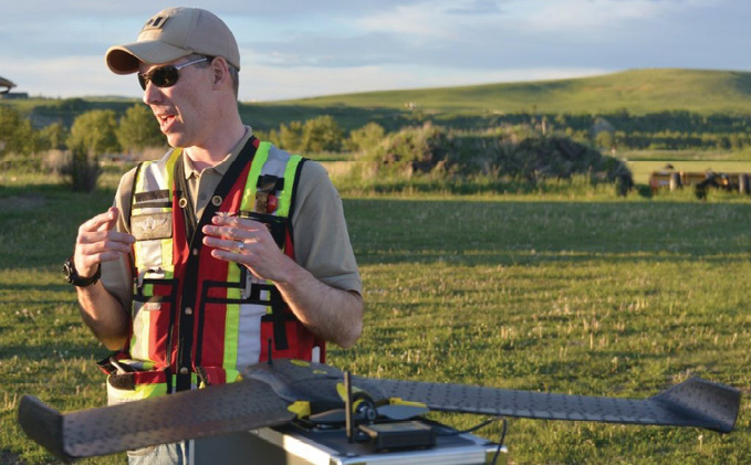 Calgary, Canada / Cheseaux, Switzerland, June 4, 2018—One of Canada’s leading commercial drone operators, IN-FLIGHT Data, this week is embarking upon Canada’s largest BVLOS UAS Operations trial to date, with support from senseFly, the industry’s leading provider of professional mapping drones and a commercial drone subsidiary of Parrot Group.
The project’s goal is to demonstrate that BVLOS UAS flights can be conducted safely and efficiently, to the benefit of all Canadians, while providing cost reductions and/or operational efficiencies for the different use-cases involved.
“We are truly excited to get the go ahead for this ambitious project,” said Chris Healy, the owner of IN-FLIGHT Data. “Working closely with senseFly and our 20 partner organisations, we’ll be collecting a huge amount of geo-accurate data—across many types of long-range drone applications—which we are confident will help contribute to the creation of pragmatic future BVLOS legislation.”
“The scope of this trial is, we believe, unique in Canada, if not the region,” added senseFly’s Regulatory Project Manager, Samuel Dépraz. “The vast amount of flight safety data and learnings that Chris’ team will collect and share will be extremely beneficial to the future growth of Canada’s commercial drone industry, and I’m sure other regulators around the world will be following this project with interest. With IN-FLIGHT Data’s extensive operational experience, the project’s diverse, committed partners, and its ‘Compliant’ senseFly drones, I’ve no doubt this trial will be a success.”
IN-FLIGHT Data’s trial will run until early November. During this time the company will aim to complete one BVLOS mission per week. Defined by the trial’s 20 partner organisations, these missions will span everything from pipeline surveys and crop mapping to landfill volume analyses, graveyard inventory assessments and even search and rescue applications.
Key trial statistics include:
- 14 different test sites: some specific Transport Canada ‘in-range’ sites, others ‘off-range’ open airspace sites in rural locations.
- 2 drones (UAS): senseFly eBee Plus & senseFly eBee
- Flights up to 10 km in length
- Over 1,500 km total linear flight distance
- More than 120 datasets: spanning both RGB and thermal infrared aerial imagery.
- Human observers will monitor flights and air traffic in order to compare their observations, for example, with operators’ ground station software experiences.
“The reasons we made this trial so large are two-fold,” said Healy. “The more data, the better the risk models Transport Canada can create, which will help them to create safety-focused BVLOS regulations that benefit everyone. And secondly, there are just so many potential BVLOS applications out there, we really wanted to explore a good number of these.”
The flight safety data collected during the trial will be provided to Unmanned Systems Canada and TC to help define BVLOS risk models for different categories of unmanned aircraft. In the case of IN-FLIGHT Data, the eBee and eBee Plus drones it will use during the trial, designated ‘Compliant’ systems by TC, fall within Canada’s TC’s proposed ‘Very Small’ (sub-1kg) and ‘Complex operations (urban)’ commercial drone categories respectively. These UAS will be operated using senseFly’s commercial-grade eMotion ground station software, which includes integrated air traffic and geo-awareness data—key to running safe BVLOS operations in non-controlled airspaces—courtesy of AirMap and uAvionix air traffic data systems.
In 2017, senseFly became the first drone operator to be granted ‘anytime’ Beyond Visual Line of Sight (BVLOS) authorisation in Switzerland, plus its systems are currently approved for BVLOS use in France, Spain, Denmark and China. senseFly was also one of several organisations that were instrumental in the success of last year’s ground-breaking Unmanned Traffic Management (UTM) demonstration in Geneva (Swiss U-space demo). The eBee Plus, eBee SQ and albris were designated ‘Compliant Unmanned Aerial Vehicles (UAV)’ by TC in August 2017, while senseFly’s original eBee drone became Canada’s first compliant fixed-wing drone back in 2015.
For More Info, visit www.sensefly.com/drones

Pointfuse Unlocks ‘As Built’ Data for BIM with Autodesk Integration
 Maidenhead, UK, 31 May 2018—Pointfuse, a software provider that converts laser scan data – known as point clouds – into 3D models, has announced its integration with Autodesk’s BIM 360 project delivery platform, the first single project platform connecng design through construction. Pointfuse has pioneered new techniques to rapidly process vast point cloud datasets into intelligent and easy to handle mesh models. This innovation will allow important ‘as built’ models to be easily incorporated into Building Information Modelling (BIM) workflows managed with Autodesk BIM 360.
“Digital Construction is about supplementing existing work flow practices in an online collaborative environment,” said Jon Boyce, CEO of Pointfuse. “Collaborative design is well established as a deliverable in digital construction. As a leading provider of robust design and construction software, Autodesk is the natural partner for us to introduce this exciting development in reality capture to achieve 4D BIM.”
“The integration of Pointfuse with BIM 360 bridges the gap between the physical and digital worlds, and allows a far more connected and efficient construction process,” says Sarah Hodges, Sr. Director, Construction Business Strategy and Marketing at Autodesk. “When reality capture data is exported to BIM 360, Pointfuse models allow easy comparison to the original design at each stage of the building process and puts all the project data into a single platform, breaking down silos that currently exist among various technologies.”
4D BIM is a way of live-tracking project progress so stakeholders can view the current status and collaborate online using the BIM 360 platform. The latest scheduling and updated costings, changes and identification of potential clashes all require timely and accurate “as built” data as an integral part of the process. “Crucially Pointfuse as built models will help with the avoidance of design clashes. This is important since, industry-wide, it is estimated that each identified clash could save up to $15,000 on a large scale project,” comments Boyce.
Democratization of data from job sites has been a process of box ticking and photography which is traditionally a manual and cumbersome process. The data compiled is considered to be of low value and rarely adopted in a complete work flow process. New rapid scanning technology offers the potential to change this, but the resulting point cloud is difficult to interpret by the untrained eye. Its use in a browser based collaborative environment is also compromised by the large data file sizes. Pointfuse addresses this with software that creates relatively small but accurate and intelligent models that are manageable within a cloud environment.
Pointfuse is available as a download from the Autodesk App store as a full integration with BIM 360.
For More Info, visit www.pointfuse.com
The Smart City at INTERGEO—Discover the Urban Future
Karlsruhe/Frankfurt, 30 May 2018—Cities of all sizes are currently working on offering their growing populations attractive, sustainable living spaces, so smart city solutions are booming. These cities are faced with huge traffic, energy, environmental, health and education challenges and each of them requires its own specific solutions. INTERGEO considers this development and the rapidly growing market for smart city solutions to be extremely important, as reflected by both the conference programme and the SMART CITY SOLUTIONS topic platform that acts as a meeting point for providers of such solutions.
The urban era has only just started. According to the latest figures from the United Nations, around three-quarters of the world’s population will be living in cities by the year 2050. This trend is even further advanced in Germany. According to a study published on the “Statista” statistics portal, some 78.6 percent of the country’s population will be living in cities by 2030. An entire generation of urban planners and developers, traffic and environmental experts, local politicians and municipal energy providers are therefore joining research institutions and EU projects in addressing the question of how to prepare cities for this additional population pressure.
What will the smart city of the future look like?
To ensure cities become attractive and adaptable living spaces in the future, cutting-edge IT is being used on a widespread basis to turn them into smart cities. But what exactly does that mean? What aspects of urban life are affected? And how are city dwellers reacting to this digitalisation of their living environment?
There is no definitive answer to any of these questions because every city is unique and has its own requirements and challenges. The starting point for every smart city is therefore to analyse local features and the goals of local authorities and the people living there. A wide range of data needs to be collected and analysed along with existing information, and the basic function of geodata is deemed extremely important in
this regard.
Basis for healthy urban growth
INTERGEO sees the smart city as a basis for healthy urban growth and is presenting itself as a platform for this dynamic sector of the economy. The topic is a focal point during all three days of the INTERGEO Conference. The “Local authorities and digitalisation”, “Smart city” and “Lighthouse city Germany” programme blocks follow the steps involved in cities becoming smart and underline the importance of geoinformation throughout this process.
Networking providers and cities at SCS
SMART CITY SOLUTIONS is a meeting point for international providers of smart city tools and the people responsible for urban development, mobility and the environment in cities and communities. Thomas Müller and Bart Gorynski from the “bee smart city” internet platform, an exhibitor and panel organiser at SMART CITY SOLUTIONS, define a smart city as an ecosystem of solutions and have the following to say: “We’re delighted to actively support SCS precisely because its fundamental objective is to highlight the many different facets of the smart city and bring together providers and the cities themselves.” Mitsubishi Electric is also exhibiting at INTERGEO. The Japanese company sees its mobile mapping system and automated mapping technologies as the basis for driverless vehicles, efficient infrastructure management and disaster protection. It regards INTERGEO as an ideal opportunity to meet partners for the future who are keen to pave the way for new, innovative business models and markets.
All this is exactly what SMART CITY SOLUTIONS is aiming for, providing a platform for providers to network and meet city representatives, and also for cities to enter into dialogue and compare their solutions.
Smart city solution providers, urban developers and planners, environmental and traffic experts, economic development specialists, urban consultants and local authorities can discover the urban future—in Frankfurt from 16 to 18 October at INTERGEO, the accompanying conference and the special part of the trade fair devoted to SMART CITY SOLUTIONS.
For More Info, visit www.intergeo.de/intergeo-en/