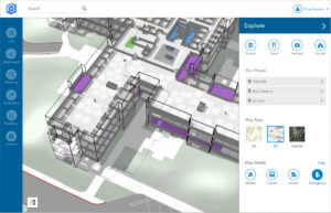
ArcGIS Indoors uses data streams, real-time processing, and location intelligence tools to help businesses and other organizations understand how to better coordinate space and other resources with their facilities and campuses. Insights from sensor networks deliver real-time information to managers and executives through interactive dashboards, while visitors and employees can find useful information about the buildings they occupy. Floor-aware, 3D maps allow building operators and occupants to quickly access and explore critical business information, like the location and status of fire extinguishers and their last inspection dates, or conference rooms and their projector options.
“ArcGIS Indoors brings the interior building space into the future by placing data about employees, schedules, meetings, customers, and events into a geographic context,” said Nitin Bajaj, product manager at Esri. “Having spatial awareness gives executives, managers, and employees better insight so they can operate more efficiently and competitively.”
ArcGIS Indoors will be available for widespread use by the end of the year. However, a beta version of the product will be released at this year’s Esri User Conference, to be held July 9–13 at the San Diego Convention Center in San Diego, California.
To learn more about how location intelligence is powering smart workplaces, visit go.esri.com/indoors .