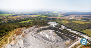
Applications like mineral extraction monitoring can all be done seamlessly within the software. Users can process raw drone data, produce point clouds and DSMs, and perform volumetric calculations, all in the same Correlator3D™ workflow.
“Our clients often require project delivery within 24 hours”, said Jennifer Waugh, Principal at Alietum Ltd., a Canadian company using unmanned technology to support construction, consulting, and government clients. “SimActive enables us to meet this demanding turnaround time.”
About Alietum Ltd.
Founded in 2016, Alietum Ltd. is based in Yellowknife, Canada and has completed projects across Northwest Territories and as far north as Victoria Island. Alietum endeavours to use emerging unmanned technology to support the unique environment, industries and people who define Canada’s north. Current clients include construction companies, consulting firms, and government agencies. For more information, visit www.alietumuav.com.
About SimActive
SimActive is the developer of Correlator3D™ software, a patented end-to-end photogrammetry solution for the generation of high-quality geospatial data from satellite and aerial imagery, including UAVs. Correlator3D™ performs aerial triangulation (AT) and produces dense digital surface models (DSM), digital terrain models (DTM), point clouds, orthomosaics and vectorized 3D features. Powered by GPU technology and multi-core CPUs, Correlator3D™ ensures matchless processing speed to support rapid production of large datasets. SimActive has been selling Correlator3D™ to leading mapping firms and government organizations around the world, offering cutting-edge photogrammetry software backed by exceptional customer support. For more information, visit www.simactive.com.