
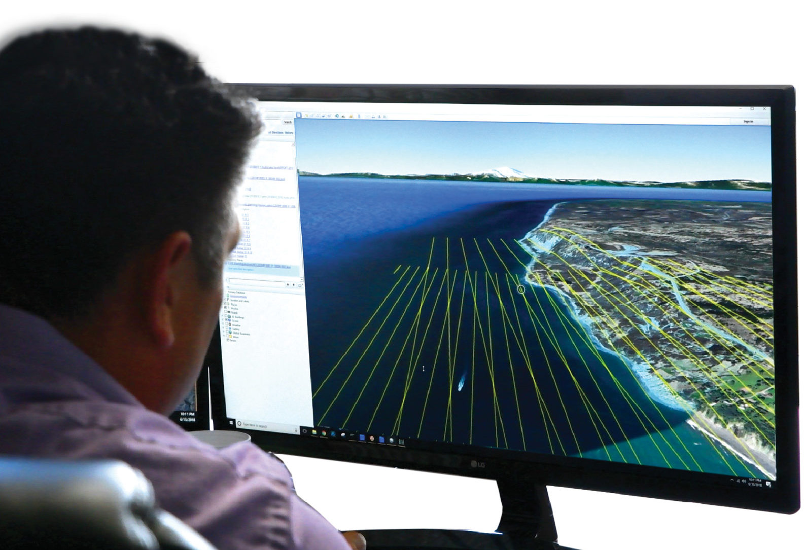
USACE Mobile Scientist Chris Macon works with lidar data collected over Alaska.
The U.S. has more than 95,000 miles of coastline1, and its effective management is vital to the economy, environment and safety of the nation. The coastline defines our maritime boundaries, is home to 40% of the nation’s population, and accounts for $8.3 trillion in goods and services annually. And—because of natural, constant and sometimes extreme change—it is a moving target.
Editor’s note: A 3.2Mb PDF of this article as it appeared in the magazine—complete with images—is available HERE.
In Alaska, which comprises more than twice the coastline of any other state2, the need for coastal data is amplified. In addition to large-scale environmental hazards like storm surge, earthquakes, volcanoes and tsunamis, the Alaska Division of Geological & Geophysical Surveys (DGGS) reports that 87% of all Alaska Native communities experience flooding damage and coastal erosion3. These natural processes destroy infrastructure, threaten personal safety and livelihoods, and increase the financial burden on state and local economies.
Even though strides have been made to survey and map Alaska4, there are many needs for baseline coastal geospatial data to effectively evaluate and monitor Alaska’s coastal regions. Alaska coastal mapping data would address data gaps that are critical to the safety of navigation, infrastructure planning, storm-surge modeling, tsunami modeling, regional erosion monitoring and emergency response.
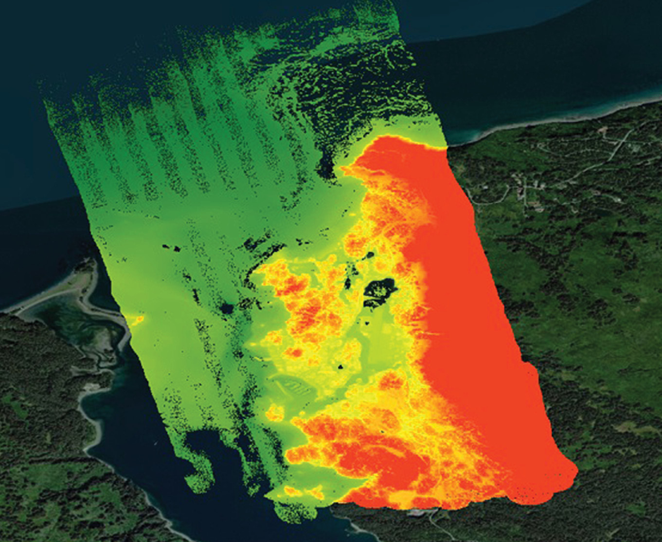
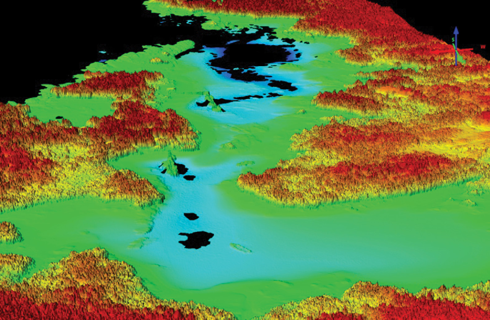
Seldovia, Alaska, is seen via lidar data.
The Joint Airborne Lidar Bathymetry Technical Center of Expertise (JALBTCX) provides airborne lidar bathymetry and complementary technologies to support the coastal mapping and charting requirements of the U.S. Army Corps of Engineers (USACE) in support of the National Coastal Mapping Program (NCMP). The NCMP’s stated goals are to develop regional, repetitive, high-resolution, high-accuracy elevation and imagery data; build an understanding of how the coastal zone is changing; and facilitate the management of sediment and projects at a regional, or watershed, scale.
JALBTCX owns and operates the Coastal Zone Mapping and Imaging Lidar (CZMIL) systems year-round and worldwide in support of the USACE and the Naval Oceanographic Office (NAVOCEANO), collecting high-resolution lidar bathymetry and lidar topography elevation data, as well as hyperspectral and true-color aerial imagery. Each summer, one of these systems transits through Alaska on its way back from supporting NAVOCEANO operations in the Pacific.
JALBTCX took full advantage of the opportunity to employ high-tech survey equipment already being utilized in Alaska to collect high-resolution bathymetric and topographic lidar data in Homer in 2018 and at multiple locations throughout the state in 2019. Since mobilizing airborne surveying and mapping equipment is expensive, leveraging this opportunity with normal operations allowed JALBTCX to cost-effectively characterize the capability of a deep-water bathymetric lidar system in new, challenging mapping environments, and to better understand logistical challenges of airborne bathymetric lidar operations in Alaska.
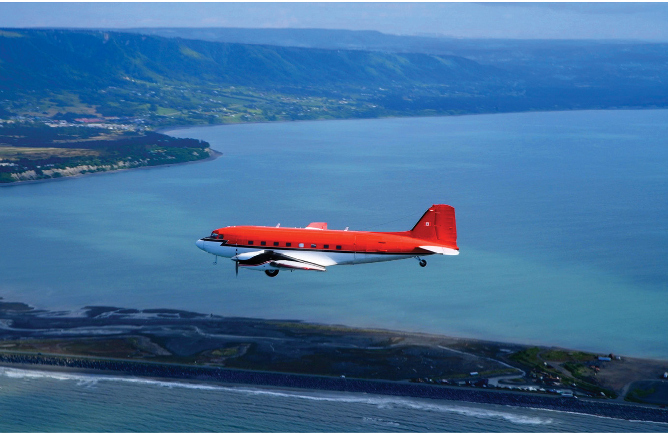
The Kenn Borek Air Balser BT-67, equipped with a Coastal Zone Mapping and Imaging Lidar system sensor, was used to collect data over Homer, Alaska. USACE personnel evaluated which sites and stakeholders would yield the greatest impact from a data use perspective, and which were likely to be operationally feasible given terrain and water clarity conditions in Alaska. Homer, a coastal town on the southern edge of the Kenai Peninsula, was identified as the first pilot area.
By coordinating these collections with federal and state partners that included the USACE Alaska District, DGGS, the U.S. Geological Survey (USGS) and the National Park Service, JALBTCX provided essential high-resolution elevation data of the coastline to effectively address the need for data to support coastal engineering, coastal storm surge modeling and tsunami modeling for communities in Alaska. Woolpert and Optimal GEO supported the USACE project through the firms’ joint venture, WMR-532.
“Alaska communities are all closely tied to the water—whether participating in sport, commercial or subsistence fishing; for transportation; or for receiving goods where roads don’t reach. Due to the proximity of communities to coastal waters and the reliance on coastal ecosystems, Alaska needs a seamless nearshore dataset that goes from land to water,” said Jacquelyn Overbeck, who manages the DGGS Coastal Hazards Program. “Lidar generates the kind of high-resolution dataset that meets Alaska’s critical shoreline mapping needs. The recent work by JALBTCX in Alaska has provided shoreline data in areas that have never been collected with topographic-bathymetric lidar, so this data is fulfilling a need that has yet to be met in the state.”
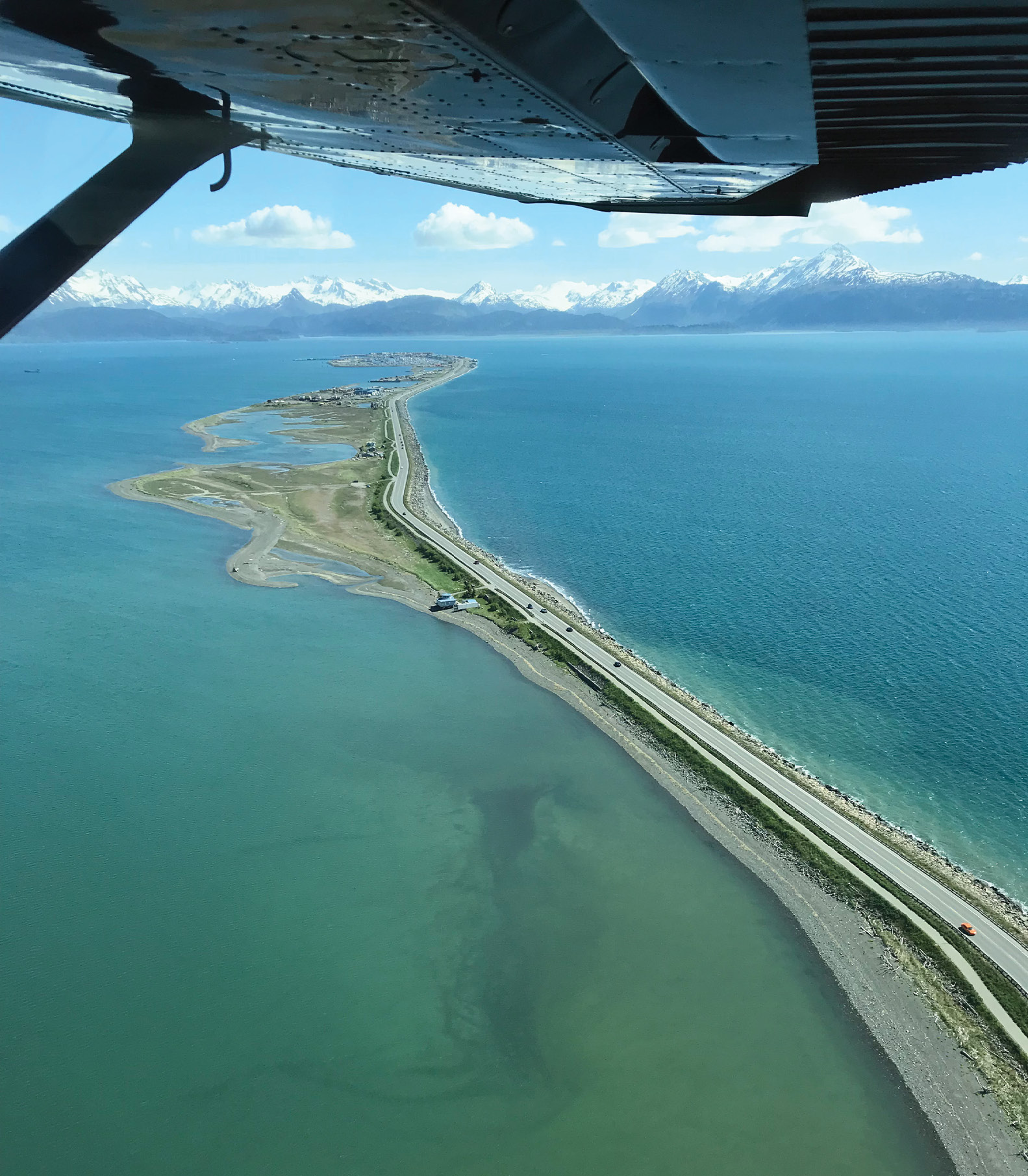
The Homer Spit is 4.5 miles long and juts out into Kachemak Bay. The dynamic landmass is challenged by accretion and erosion due to regularly occurring storms and seasonal tides.
Developing a strategic plan
Marta Kumle, Alaska coastal mapping strategist, is leading the development of the Alaska Coastal Mapping Strategic Plan. An assessment was conducted to determine the data needs of state, regional, federal, academic, professional and nonprofit organizations. The data needs support a wide range of applications, such as engineering and hazard mitigation, land management, national resource management, emergency response, vessel navigation and general knowledge for miscellaneous applications.
A grading system was created to evaluate the quality of existing public elevation data that included bathymetry, topography, orthoimagery and shoreline vector data. The data was then integrated with information from a stakeholder survey to develop spatial prioritization to support a five-year strategic plan for data acquisition. To grade the existing continuous and overlapping topographic-bathymetric datasets, an algorithm was applied that factored in the age of the dataset, its resolution and the quality of the technology used to collect it.
“The plan aims to strategize data acquisition in our state to meet as many stakeholders’ needs as possible, so data can be used for many times for different purposes,” said Kumle. “Drawing on the grading system and survey results, the strategic plan will be a roadmap to meet requirements and mapping priorities for the longest state shoreline in the United States.”
John Gerhard, Woolpert vice president and director of maritime solutions, said that the goals of developing a strategic coastal mapping plan in Alaska include assisting the state in defining and assembling coastal mapping priorities, encourage collaboration in data collection, and attracting state, federal and partner funding to invest in the coastal mapping requirements.
“Alaska has more than 280 coastal, riverine or lakeside communities spread across its vast geography that are not connected by roads,” Gerhard said. “Shorelines are rapidly changing due to erosion, storm surges are flooding communities and displacing populations, and the stability of existing infrastructure is at risk. Accurate, high-resolution geospatial data is essential to prioritize and address Alaska’s coastal mapping requirements.”
Mapping in Alaska
To begin its mapping project, USACE personnel evaluated which sites and stakeholders would yield the greatest impact from a data-use perspective, and which were likely to be operationally feasible given terrain and water clarity conditions. Homer, a coastal town on the southern edge of the Kenai Peninsula, was identified as the first pilot project area.
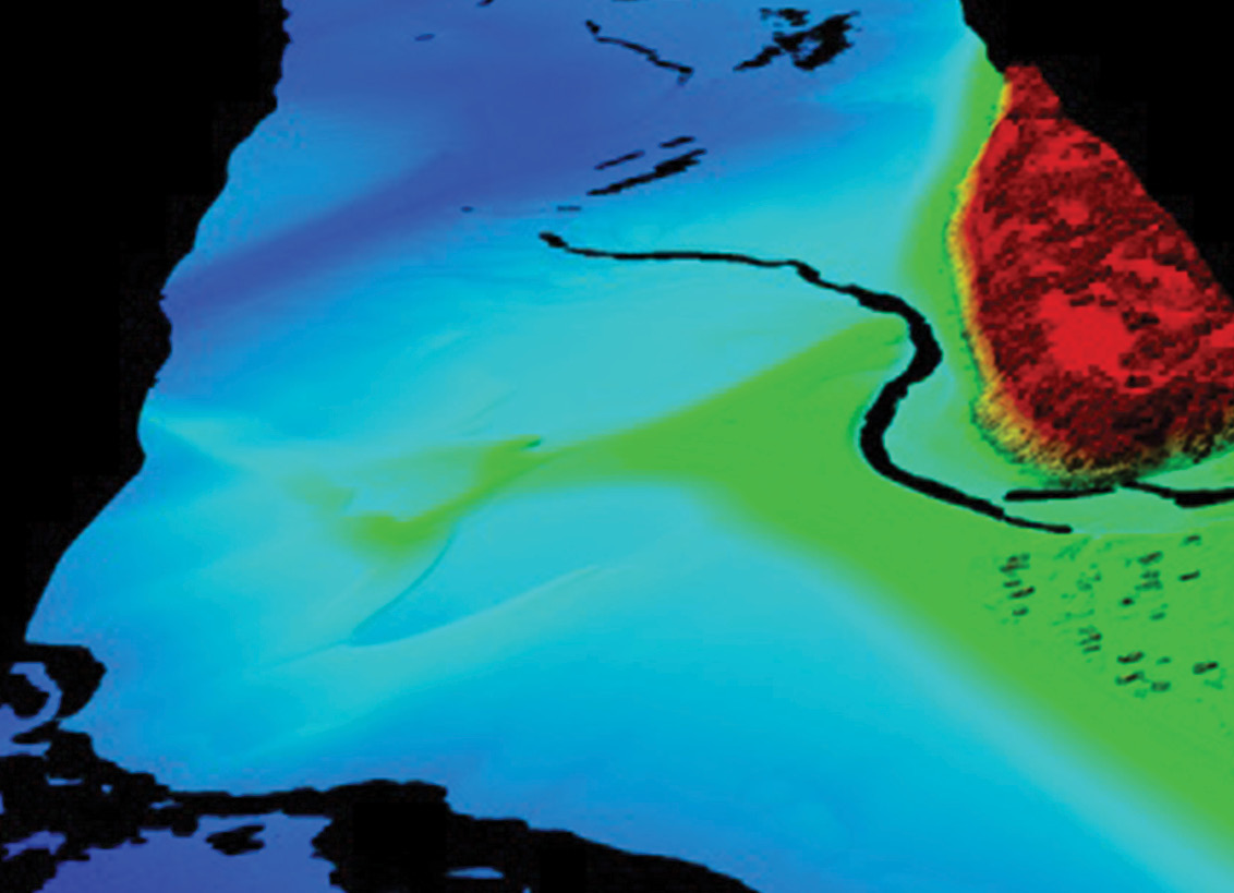
Lidar data illustrates Port Alexander, Alaska.
Multiple geologic hazards such as coastal flooding, tsunamis, earthquakes and slope instability impact Homer’s nearly 5400 residents, many of whom have homes on high-elevation coastal bluffs. The city’s most notable feature is the Homer Spit, a 4.5-mile long, narrow finger of land that juts out into Kachemak Bay. The Spit is a dynamic landmass that is challenged by accretion and erosion due to regularly occurring storms and seasonal tides.
Enhanced elevation datasets have been sought to address and improve hazard modeling, provide technical assistance for the city to develop a setback policy for building near coastal bluffs and aid the City of Homer Port and Harbor, which supports a diverse commercial fishing fleet and thriving marine industrial and maritime transportation industries.
“This data being collected will be very valuable for us as we expand the harbor systems and create a large-vessel harbor, which we’ve been planning for years,” Homer port director/harbormaster Bryan Hawkins said. “It will help mitigate navigational hazards and will help us work with the USACE to develop a dredged materials guidance plan for the Homer Spit.”
For the Homer mission, the JALBTCX survey crew had planned 12 flight hours over three days in June 2018. That quickly evolved into 14 hours to accommodate local tidal conditions within Alaska’s already narrow collection window, rugged terrain and dense canopies of kelp fields. “The coastline of Alaska has many differing conditions, creating data collection and processing challenges,” said Mark Brooks, Optimal GEO chief operating officer. “The team’s ability to identify these challenges and to quickly modify the survey plan allowed us to produce a successful project.” The 14 flight hours successfully produced 47 flight lines over the 25.5 miles of Homer’s beach and shallow water seafloor, reaching a maximum depth of 21.4 m and yielding 406 million valid topographic and bathymetric measurements.
In July 2019, the crew returned to Alaska to conduct additional survey operations at multiple locations in acute need of data by federal and state partners for multiple applications. Sites were selected by the USACE Alaska District based on feasibility of airborne operations and probability of success of bathymetric lidar to fulfill the seamless topo-bathy mapping data needs. Airborne bathymetric lidars typically operate at 400 m altitude and require relatively clear water for depth measurements. The rule of thumb for deep-water bathymetric lidars like CZMIL is depth measurement from two to three times the Secchi depth, or visible depth of the water. Between July 9 and July 27, the flight crew flew 18 missions for 13 priority areas, collecting 416 square miles of topographic and bathymetric lidar data. Mapped locations include Little Diomede Island, Golovin, Port Clarence, Point Hope, Seldovia, Unalakleet, Voznesenka, and the Gulf of Alaska from Lituya Bay to Palma Bay.
“The Alaska Coastal Mapping Strategic Plan and the communities most affected by coastal hazards were considered when coastal storm surge and tsunami modeling priorities were selected for the 2019 survey operations,” Overbeck said. “With the assistance of JALBTCX, we have several enhanced elevation datasets that help meet the goals of a comprehensive and coordinated plan to map Alaska’s coast.”
Crews accommodated local tidal conditions within Alaska’s already narrow collection window, and the consistent threat of inclement weather.
The flight crew was based at three airports during the flight operations: Anchorage, Juneau and Nome. The crew logged 102 flight hours, 53 online survey hours and 39 transit hours. The transit hours included flight time between the survey locations from these airport bases, as well as the additional flight time incurred when inclement weather diverted the aircraft to another airport. The trajectory information and data coverage were reviewed daily by deployed USACE Operations and Woolpert staff at a field office in Anchorage, and the final data products were produced at the JALBTCX Stennis office by USACE and Optimal GEO staff. The final data products included the classified point cloud in LAS format, digital surface models, digital terrain models, RGB imagery at a 5 cm pixel resolution and 48-band hyperspectral imagery at a 1 m pixel. Additional products generated at the request of local stakeholders included a subaquatic vegetation classification, yielding additional biome and environmental applications.
Challenging aspects of these projects included complex, turbid and temporally dynamic shallow deltas in the Golovin area, as well as rocks located in many areas of the littoral interface. This complicated light absorption and multipathing inputs during the data validation process.
Ninilchik, Alaska, is seen via lidar data.
Map once, use many times
The Alaska Coastal Mapping Strategy and supporting JALBTCX surveys in Alaska exemplify the concept of “map once, use many times,” promulgated by the U.S. Interagency Working Group on Ocean and Coastal Mapping5. With coordination among as many stakeholders as possible early in the survey planning process, a single data collection can meet the data requirements of many data users and a broad range of applications.
Woolpert program director Mark Smits said that these types of projects support Alaska’s coastal mapping needs by improving the quality and quantity of the critical baseline data of shoreline conditions in Alaska, and they support the needs of people and programs around the world. “Due to its high resolution and fidelity, this data can be used across countless domains by multiple agencies and for multiple applications—providing each with timely and accurate information,” Smits said. “Lidar bathymetry and topography are not only employed by the USACE, NAVOCEANO and others around the world, but they enable the DGGS to coordinate its goals with programs like the NCMP to benefit both. To have accomplished this collection efficiently and within a challenging environment such as Alaska is a win for all involved.”
All images and data are courtesy of the USACE National Coastal Mapping Program.