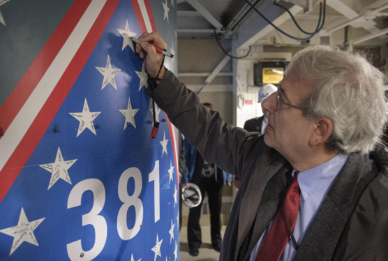
Michael Freilich, director of NASA’s Earth Science Division, NASA Headquarters, signs a star on the United Launch Alliance Delta II with ICESat-2 onboard, on Thursday, September 13, 2018, at Vandenberg Air Force Base in California. This was the final launch of a Delta II rocket. The “381” on the rocket signifies that it was the 381st flight in the Delta family. The first Delta I was launched in May 1960. Courtesy of NASA.
Writing this on board a Lufthansa flight to Germany to participate in the mid-term symposium of ISPRS Technical Commission I, entitled “Innovative Sensing—from Sensors to Methods and Applications”, in Karlsruhe, then the enormous Intergeo trade show in Frankfurt, I look forward eagerly to learning about the latest scientific and commercial developments. The Karlsruhe event enables scientists working on topics on the ISPRS agenda to report on their findings midway between the quadrennial congresses. In Frankfurt, representatives of hundreds of companies will be enthusiastically proselytizing the latest products and services. The struggle will be to see everything important in only three days. It will be marvelous!
These delights scarcely allow breathing space from my last two excursions. On September 15, 2018, thanks to the magnanimousness of Sigma Space (part of Hexagon) and NASA, I was present at Vandenberg Air Force Base in California to witness the launch of ICESat-2 (Ice, Cloud and land Elevation Satellite). This was a once-in-a-lifetime experience and a great honor. Thanks again to Sigma Space, I am able to report in this issue on aspects of the single-photon technology on which this mission is based, especially the detector array, which provides incredibly precise timing for the sole instrument on ICESat-2, the Advanced Topographic Laser Altimeter System (ATLAS). The ATLAS laser emits visible, green laser pulses at a wavelength of 532 nm. ATLAS splits the laser into six beams, arranged in three pairs, with 3.3 km between pairs; it fires at a rate of 10 kHz, enabling points on the ground to be captured at 70 cm spacing along track. NASA is predicting that, after full post-processing, changes in elevation can be measured to a precision of about a quarter of an inch. ICESat-2 acquires data from all over the Earth’s surface, but the polar regions are of special interest as we worry about our changing planet.
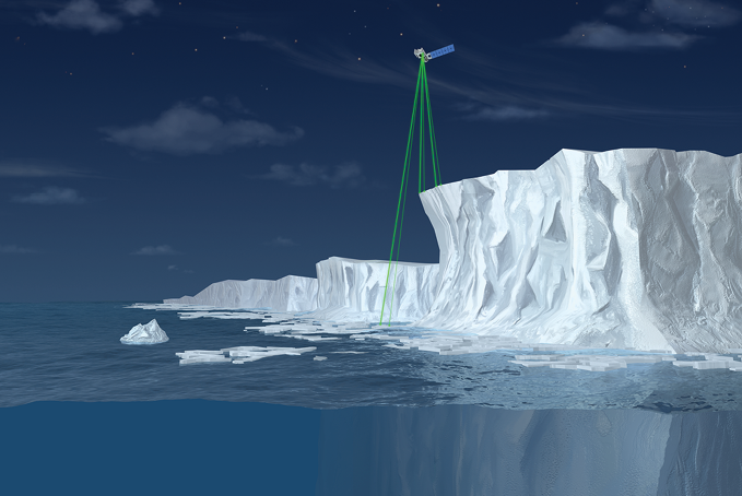
ICESat-2 uses six laser beams to measure the height of ice, as illustrated in this not-to-scale artist’s rendering. This illustration is an outcome of the ICESat-2/SCAD Collaborative Student Project. Courtesy of NASA
The launch was preceded by several events, most of them open to the public, in Solvang and Lompoc, small towns just east of Vandenberg. The commitment, as well as the brilliance, of the NASA scientists shone through and it’s worth remembering that some of them have devoted ten years—a substantial part of their working lives—to ICESat-2. I bumped into an ebullient Marcos Sirota, CEO of Sigma Space, in the hotel after one of the presentations. The joy, seen on NASA TV, as the United Launch Alliance Delta II launch vehicle erupted from its pad, was palpable and easy to share. The launch had been delayed a few days as some critical team members had been in Florida for the launch of the Parker Solar Probe. There was a further short delay during countdown, as the team waited for the temperatures of some of the chemicals on board the launch vehicle to fall within the required window. Finally, the “Go ICESat-2” decision was made. This was the 155th successful launch of the Delta II, which entered service in 1989, but also its last as it is being superseded. What a privilege to be there. The process in the minutes after launch was a complex one, with various parts of the launch vehicle being detached and several engine burns, until the separation, 79 minutes after launch, of the last of four cubesats, carrying sensors designed by universities. This unfolded on NASA TV as we were bussed back to the hotel and there was a flutter on board as each success was reported. ICESat-2 is a continuation of ICESat, which flew from 2003 to 2009, providing invaluable elevation data. NASA tried to fill the gap with IceBridge, a series of airborne missions, during the intervening years. The performance of ICESat-2, of course, is in a different world from ICESat, a manifestation of the spectacular developments in lidar itself: we have seen the single-photon approach enhance the airborne lidar environment, while incremental improvements in pulse rates and so on have been enhancing lidar for years. At the time of writing, the mission is proceeding according to plan: the satellite is orbiting as planned at an altitude of 496 km, the laser began operating about two weeks after launch, the ATLAS instrument is working well and elevation data of Antarctica was produced by 3 October.

During the integration of Drone World Expo into Commercial UAV Expo, Diversified Communications sought the involvement of renowned UAV experts from international law firm Hogan Lovells. Here Lisa Ellman (above) engages in a plenary discussion with Michael Kratsios, Deputy Assistant to the President for Technology Policy, and Gretchen West (below) with Earl Lawrence, FAA’s Director, Office of Unmanned Aircraft Systems Integration. Images courtesy of Diversified Communications.
Shortly after the above confirmation that NASA’s budget is well spent and enables the most wonderful work, I moved rather closer to the ground, traveling to Las Vegas for the fourth Commercial UAV Expo, run by Diversified Communications (“DivCom”), which in 2017 acquired another UAV conference, Drone World Expo, with the result that the integrated event attracted 2350 attendees from 1300 organizations, all 50 states and 40 countries; and 168 exhibitors in a buzzing exhibition. The event was rounded out with workshops, a university roundtable discussion and ASPRS sessions. Once again DivCom ran a fine show, starting with outdoor demos on the Monday: not only did two of these feature VTOL aircraft—from AeroVironment and Autel Robotics—and the third, a C-ASTRAL aircraft that was launched from a catapult and landed with the help of a parachute, but the venue itself mattered. This was the Henderson Unmanned Vehicle Range, an initiative of Nevada Institute for Autonomous Systems (NIAS) and 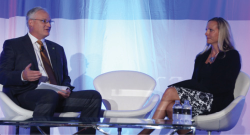 Nevada State College. Rather bare of vegetation, the site featured a strip of astroturf as a “runway”, reminding me of a cricket pitch in the more arid parts of the world! After opening words from DivCom director Lisa Murray, there was a moment of silence to commemorate the first anniversary of the Mandalay Bay mass shooting on 1 October 2017 (DivCom announced a forthcoming donation to Route91Strong). Chris Walach (NIAS) welcomed us and stressed safety. The state-of-the-art headquarters on site and the huge number of personnel in yellow jackets with radios, pick-up trucks, Humvees and so on, reinforced his message! There is plentiful evidence that initiatives to foster UAV activity bear fruit. Complementary examples came in two marketing pieces I picked up in the exhibition. One was a thick booklet from the Province of Alberta describing organizations involved in UAVs. The other was a leaflet from GGBa (Great Geneva Bern Area) in Switzerland, with concise explanations of its incubator role. The Swiss UAV concentration, of course, is well known and includes the famous Pix4D and senseFly companies, both now part of Parrot Business Solutions, which has acquired several companies and developed affiliations to others, such as MicaSense, in order to offer comprehensive solutions to its customers. Its well known eBee aircraft, however, still lacks the payload capacity for lidar—the same could be said for the Gateway/Trimble winglet that is now the Delair UX11. There were, of course, numerous big UAVs on show that can carry lidar easily and we hope to have articles on projects featuring some of these in the future. But it was intriguing that performance in terms of endurance seems to have taken off, with rather few suppliers reporting the 20-minute battery life that made us anxious only a couple of years ago. Better batteries are part of this—and the US-1 rotorcraft from Impossible Aerospace was presented as an aircraft built round the batteries (photogrammetrists will remember that this product name was the same as an analytical stereoplotter launched by Helava Associates at the 1976 ISP Congress in Helsinki!)—but other technologies are playing a growing role, for example high-performance chargers tuned to particular battery models, or solar, with lightweight, flexible panels suited to the upper surfaces of fixed-wing UAVs.
In a new feature of the conference, called “Pitch to the Press”, we gentlepersons of the press scoured the exhibition to find interesting products, of which the most promising were selected and the suppliers invited to give five-minute pitches. A winner was chosen and DivCom issued a press release. This was eclectic but fun. On the other hand, couldn’t the format of the product previews on the Monday afternoon, which are invaluable but rather an endurance test, with two parallel four-hour sessions consisting of 15-minute presentations from 32 vendors, be freshened and shortened?
You may remember the LIDAR Leader Awards from last year, run jointly by LIDAR Magazine and Diversified Communications, where we had more than 80 nominations, gave three awards and fomented a new impetus. This year we’ve added two new categories, for innovation and university achievement. Again the nominations are flowing in.
We began this note with ICESat-2 and its detector array. To put this in perspective, it is a tiny component of the payload propelled into space that day from Vandenberg—but its performance is essential to mission success. In a similar vein, an article caught my attention recently: Hank Hogan, on the editorial staff of Photonics Spectra, penned a short piece on remarkable ongoing improvements to filters and cited their importance not only to imagery but to automotive lidar, for which the requirement is narrow filters with flat tops and the highest possible transmission1. We can all see the continuous advances in the information generated from lidar systems. Sometimes it is salutary to reflect on the scientific brilliance, as well as persistence, behind the small as well as the large components that make the breakthrough.
1 Hogan, H., 2018. Better filters yield better sensor performance, Photonics Spectra, 52(8): 34-38, August.